2009
NS3974 : Dumbarton Castle: western curtain wall
taken 15 years ago, near to Dumbarton, West Dunbartonshire, Scotland
This is 1 of 4 images, with title Dumbarton Castle: western curtain wall in this square
Dumbarton Castle: western curtain wall
[This is one of a linked series of articles about Dumbarton Rock. See the end of Link for a list of the reference works that are cited here in abbreviated form.]
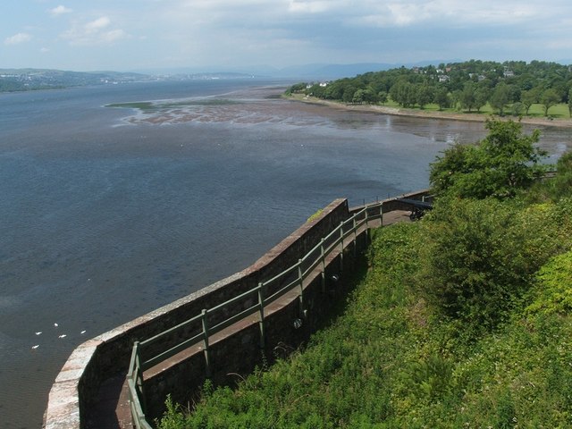
This photo shows a stretch of the western defensive wall; right of centre, a cannon marks the location of the Spanish Battery, which was built in about 1735 as part of a general strengthening of the castle's southern and western defences, prompted by fears of a Jacobite invasion [MacPhail, 144]; see also NS4074 : Dumbarton Rock: King George's Battery.
(For a view along the wall in the opposite direction, see NS3974 : Dumbarton Castle: western curtain wall.)
The battery was strengthened in about 1790 to take heavier guns [OSG07, p5]; compare: Link
In the background, on the right, is the wide mouth of the River Leven as it flows into the Clyde. The foreshore area of Levengrove Park can be seen behind it.
Previous: NS4074 : Dumbarton Rock: sentry box and curtain wall.
Next: NS3974 : Dumbarton Rock: Bower Battery.
Dumbarton Rock and Castle :: NS4074
The Rock is a volcanic plug, and it has a long history as a fortified site. For further information, see the Geograph article "Dumbarton Rock and Castle": Link
 Map © Crown Copyright")
TIP: Click the map for more Large scale mapping
- Grid Square
- NS3974, 267 images (more nearby 🔍)
- Photographer
- Lairich Rig (more nearby)
- Date Taken
- Friday, 26 June, 2009 (more nearby)
- Submitted
- Thursday, 2 July, 2009
- Subject Location
-
OSGB36:
 NS 3991 7443 [10m precision]
WGS84: 55:56.1713N 4:33.8680W - Camera Location
-
OSGB36: NS 3994 7441
- View Direction
- West-northwest (about 292 degrees)