1987
NT4334 : Staff Huts at the former Peel Hospital near Galashiels
taken 37 years ago, near to Caddonfoot, Scottish Borders, Scotland
Staff Huts at the former Peel Hospital near Galashiels
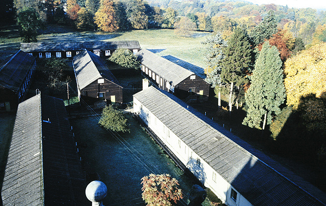
These staff huts viewed from the roof of Peel House are, from the back, Hut D; in the middle from left to right, Huts A,B and C; and in the foreground, Hut G on the left with Hut H on the right. In 1939 Lord Craigmyle handed over Peel House and its grounds on trust to be used as a hospital for service patients. Peel Hospital was built as an emergency medical service hospital and after the war, in 1948 when the NHS came into being, the hospital was used for the treatment of civilian patients. Permission was also granted to set up a training school for nurses. The hospital consisted of the mansion house which acted as a medical and senior nursing staff residency, dining room, kitchen and recreation area, and a number of standard wooden war time huts used as wards and support service areas. The Peel site was closed in April 1988 and all services transferred to the new Borders General Hospital NT5333 : The Borders General Hospital at Huntlyburn in Melrose. Many of the staff who worked here still have fond memories of the hospital and the camaraderie of the place, something that was somehow missing when the new hospital opened.
 Map © Crown Copyright")
TIP: Click the map for more Large scale mapping
- Grid Square
- NT4334, 74 images (more nearby 🔍)
- Photographer
- Walter Baxter (more nearby)
- Date Taken
- Friday, 23 October, 1987 (more nearby)
- Submitted
- Thursday, 29 October, 2009
- Subject Location
-
OSGB36:
 NT 432 348 [100m precision]
WGS84: 55:36.2089N 2:54.1839W - Camera Location
-
OSGB36: NT 433 348
- View Direction
- WEST (about 270 degrees)