2010
SZ0690 : Branksome: postbox № BH13 148, Tower Road West
taken 14 years ago, near to Branksome Park, Bournemouth, Christchurch & Poole, England
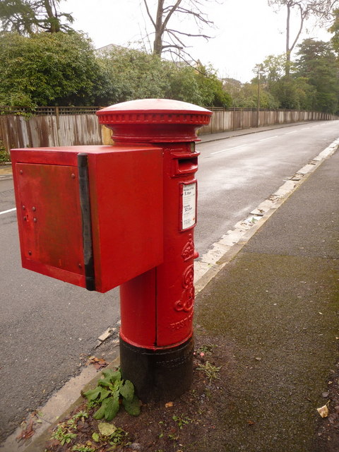
Branksome: postbox № BH13 148, Tower Road West
Having photographed most of the postboxes in the Bournemouth area, with help from the Royal Mail's list of boxes, this one was rather vexing. The list is generally pretty good at describing the location, such as the names of two roads on whose corner a box is situated. This one is described on the list as "Temporary box due to bomb damage" which was most unhelpful.
Anyway I solved the riddle after receiving an email from a chap who is in charge of painting Dorset's postboxes and he told me that it would be found here. The 'temporary' box appears to have found a permanent replacement.
The Edward VII-reign postbox is emptied finally at 5:30pm on weekdays and at 12:15pm on Saturdays.
Drop box
A drop box is an item of Royal Mail street furniture. It is a receptacle where the postman can securely store part of his morning round, at a convenient location. Sometimes, the Royal Mail van may drop off the postman with his bike and morning deliveries, saving him carrying a heavier load or frequent returns to the sorting office.
Originally drop boxes were attached to pillar boxes and, therefore, painted red to match. Nowadays, they are separate free-standing boxes usually close to a postbox generally painted grey, although red stand-alone boxes are also to be seen.
 Map © Crown Copyright")
TIP: Click the map for more Large scale mapping
- Grid Square
- SZ0690, 51 images (more nearby 🔍)
- Photographer
- Chris Downer (more nearby)
- Date Taken
- Sunday, 28 February, 2010 (more nearby)
- Submitted
- Sunday, 28 February, 2010
- Subject Location
-
OSGB36:
 SZ 063 903 [100m precision]
WGS84: 50:42.7811N 1:54.7280W - Camera Location
-
OSGB36: SZ 062 903
- View Direction
- East-northeast (about 67 degrees)