J3373 : Nos 27-37 Adelaide Street, Belfast
taken 14 years ago, near to Belfast, Co Antrim, Northern Ireland
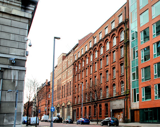
The former Ireland Bros linen warehouse, built in 1905, at 27-37 Adelaide Street. There was a planning permission (Z/2008/2087/F - 27 January 2010) as follows: Regeneration and extension of vacant warehouse to include extension to rear, removal of floor 5, the incorporation of 4 new floors with a set back at levels 5 and 6 and 7 and 8. Uses to include retail (Class A1) and restaurant/ organic food hall on ground floor with canopy, 39 live work units on floors 1-4 and 7-8 and office use on floors 5 and 6. (Amended Plans). The building is not listed but was officially described as A six-storey former warehouse located on Adelaide St, Belfast city centre. Plainly detailed, with replacement top floor. This building was surveyed in the First Survey but not listed. A partial record only was taken during the Second Survey as the building is not worthy of a full survey.
The photographs submitted by me appear as a matter of record only. I have no connection with any of the parties involved in the proposed redevelopment or letting.
![Creative Commons Licence [Some Rights Reserved]](https://s1.geograph.org.uk/img/somerights20.gif)
|
· Find out How to reuse this image ·
Share:
|
|||||
|
There are 2 posts in a
discussion on J3373 (preview on the left) |
Suggest an update to this image | Contact the contributor | |||
- Grid Square
- J3373, 2776 images (more nearby
 )
)
- Photographer
- Albert Bridge (find more nearby)
- Date Taken
- Sunday, 28 March, 2010 (more nearby)
- Submitted
- Sunday, 28 March, 2010
- Category
- Building (disused) (more nearby)
- Subject Location
-
Irish:
 J 339 738 [100m precision]
WGS84: 54:35.6920N 5:55.7004W - Camera Location
-
Irish: J 339 738
- View Direction
- South-southwest (about 202 degrees)
Other Tags