N4138 : Near Tyrrellspass
taken 17 years ago, near to Tyrrellspass, Co Westmeath, Ireland
Near Tyrrellspass
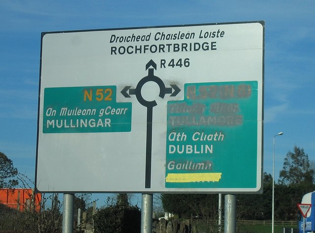
Back in April '07 the new N6 (now M6) was open only as far west as Tyrrellspass. The new N52 to Mullingar was open, but only as far as the old N6, at a roundabout where the old N6 (re-designated the R446) met the then current N6 and a stub (which later became part of the N52) to the newly opened N6 (later M6). This sign makes perfect sense if you travel back in time and know exactly where you are.
![Creative Commons Licence [Some Rights Reserved]](https://s1.geograph.org.uk/img/somerights20.gif)
|
· Find out How to reuse this image ·
Share:
|
|||||
| Start a discussion on N4138 | Suggest an update to this image | Contact the contributor | |||
Loading map... (JavaScript required)
- Grid Square
- N4138, 2 images (more nearby
 )
)
- Photographer
- Sarah777 (find more nearby)
- Date Taken
- Wednesday, 4 April, 2007 (more nearby)
- Submitted
- Saturday, 3 April, 2010
- Category
- Road signs (more nearby)
- Subject Location
-
Irish:
 N 418 381 [100m precision]
WGS84: 53:23.5088N 7:22.2657W - Camera Location
-
Irish: N 418 381
- View Direction
- Northeast (about 45 degrees)
Image classification(about):
Supplemental image
This page has been viewed about 74 times.
View this location:
KML (Google Earth) ·
Google Maps ·
Bing Maps ·
Geograph Coverage Map ·
More Links for this image
·
Bing Maps ·
Geograph Coverage Map ·
More Links for this image