C2737 : Donegal: Knockalla Fort
taken 14 years ago, 3 km from Glenvar, Co Donegal, Ireland
This is 1 of 2 images, with title Donegal: Knockalla Fort in this square
Donegal: Knockalla Fort
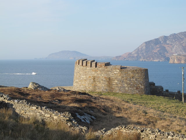
Knockalla Fort (Elevation 28 metres 92 feet) was built in 1810 by the British as a defence against possible French invasion of Ireland. The fort was one of six built on Lough Swilly and acted as the main headquarters. It consists of a Martello tower with walls 11 foot thick and faced with sandstone to minimise the effects of shrapnel on the men below during attack. Inside the fort there are two wells; one is located at the foot of the tower and the second, if the siege took a turn for the worst, inside the tower itself. The fort and surrounding grounds were sold in the 2000s for 740,000 euro.
In the background is Fort Dunree, Urrishills and in the distance Dunaff Head. Discovery Map Series 2: Map Ref. C27128 37038
In the background is Fort Dunree, Urrishills and in the distance Dunaff Head. Discovery Map Series 2: Map Ref. C27128 37038
![Creative Commons Licence [Some Rights Reserved]](https://s1.geograph.org.uk/img/somerights20.gif)
|
· Find out How to reuse this image ·
Share:
|
|||||
| Start a discussion on C2737 | Suggest an update to this image | Contact the contributor | |||
Loading map... (JavaScript required)
- Grid Square
- C2737, 5 images (more nearby
 )
)
- Photographer
- Michael Murtagh (find more nearby)
- Date Taken
- Sunday, 11 April, 2010 (more nearby)
- Submitted
- Tuesday, 25 May, 2010
- Category
- Fort (more nearby)
- Subject Location
-
Irish:
 C 27128 37038 [1m precision]
WGS84: 55:10.7834N 7:34.4969W - Camera Location
-
Irish: C 27128 37038
- View Direction
- Northwest (about 315 degrees)
This page has been viewed about 1184 times.
View this location:
KML (Google Earth) ·
Google Maps ·
Bing Maps ·
Geograph Coverage Map ·
More Links for this image
·
Bing Maps ·
Geograph Coverage Map ·
More Links for this image