NT2673 : Waverley Station
taken 14 years ago, near to Edinburgh, Scotland
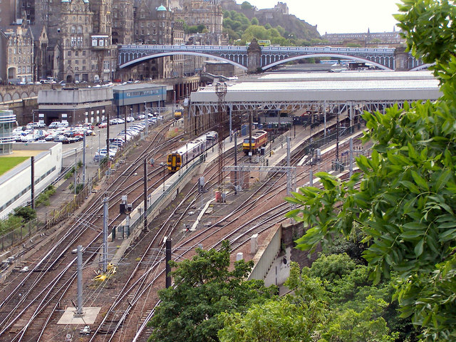
Waverley Station is Edinburgh's main train station. Covering an area 25 acres, it is the largest mainline station outside of London. Waverley forms the northern termini for the East Coast Main Line and the Edinburgh branch of the West Coast Main Line.
The station is situated in a steep, narrow valley between the medieval Old Town and the 18th century New Town. Princes Street, Edinburgh's main shopping street, runs along the northern side of the station and there are bridges at both ends. North Bridge, a three-span iron and steel bridge built in 1897, passes high above the station's eastern section, and Waverley Bridge, to the west, provides one of the three main entrances to the station. The other entrances are the northern entrance via Waverley Steps from Princes Street and Market Street to the South.
The station was originally developed in 1854 when the North British Railway Company joined three existing railway stations on adjacent sites together. It was expanded in the 1890s to handle increased traffic after the opening of the Forth Rail Bridge. Waverley is now operated by Network Rail and currently has 18 platforms in use.
LinkEdinburgh Guide
Link
Link
 Map © Crown Copyright")
- Grid Square
- NT2673, 2367 images (more nearby 🔍)
- Photographer
- David Dixon (more nearby)
- Date Taken
- Wednesday, 2 June, 2010 (more nearby)
- Submitted
- Tuesday, 8 June, 2010
- Subject Location
-
OSGB36:
 NT 261 739 [100m precision]
WGS84: 55:57.1525N 3:11.0883W - Camera Location
-
OSGB36: NT 263 739
- View Direction
- West-southwest (about 247 degrees)