TF9440 : The Massive Ramparts and Ditches
taken 14 years ago, near to Warham, Norfolk, England
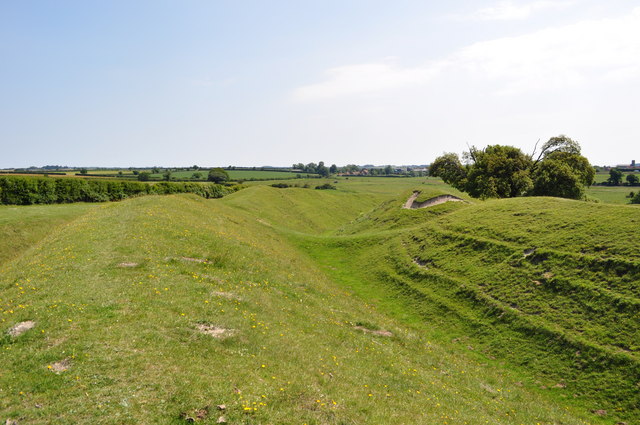
Warham Fort (or camp) is a well preserved Iron Age fort situated between Wighton and Warham. The fort is by far the best preserved in East Anglia. Others unfortunately being mostly ploughed in. Constructed next to a river bend by the river Stiffkey it was a major undertaking for the Iceni tribe. Dated from 200BC it lasted until the 1st century AD.
Two massive ditches and two tall ramparts guard a 1.5 hectare central area. Excavations of the ditches and ramparts found they were originally a further two metres deeper. The gleaming white chalk and palisade fencing would have put any invader off. It is thought it could have been built for the higher in society.
Originally the fort was a complete circle but in the 1700s works to straighten the river took parts with it, also possibly the entrance.
Roman pottery and tiles suggest the site was re-used by the Romans and that a building was inside.
Today the site is open to visitors but quite difficult to find without a map. A two gated track leads to the site and there is no parking.
 Map © Crown Copyright")
- Grid Square
- TF9440, 79 images (more nearby 🔍)
- Photographer
- Ashley Dace (more nearby)
- Date Taken
- Saturday, 26 June, 2010 (more nearby)
- Submitted
- Sunday, 27 June, 2010
- Subject Location
-
OSGB36:
 TF 944 408 [100m precision]
WGS84: 52:55.8004N 0:53.5045E - Camera Location
-
OSGB36: TF 944 409
- View Direction
- SOUTH (about 180 degrees)