2011
NS3974 : Fallen boulder beside Dumbarton Rock
taken 13 years ago, near to Dumbarton, West Dunbartonshire, Scotland
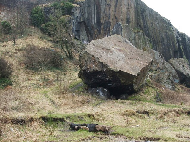
Fallen boulder beside Dumbarton Rock
This is easily the largest of several huge boulders that have broken off from the western side of Dumbarton Rock. The part of the Rock from which the landslip originated can be seen behind the boulder.
These rocks did not fall in historical times (despite a local tale, current in the nineteenth century, though probably not taken seriously even then, that the boulder's fall had crushed a milkmaid).
The present view does not adequately convey the sense of scale (partly because the view direction is aligned with the long axis of the boulder, making it seem smaller than it really is), but see NS3974 : Dumbarton Rocks, where the same boulder is the largest of those that can be seen lying at the base of Dumbarton Rock, below and to the left of the dip between its two peaks. The boulder is also visible in a picture of NS3974 : Black Lair.
The boulder and the flat-sided slopes behind it are composed of basalt, the material of which the Rock as a whole is made. Dumbarton Rock is a volcanic plug. The book "Geology Explained Around Glasgow and South-West Scotland, Including Arran" (J.A.Lawson and J.D.Lawson, 1976) discusses Dumbarton Rock in some detail, and then says, regarding the formation of such volcanic plugs:
"The last magma to cool and solidy in the vent is usually very resistant to erosion and very often stands up above the surrounding country. Many such plugs can be seen round Glasgow, often with names prefixed by 'Dun' or 'Dum' because these hills were easily defensible and some have the remains of forts on their summits. ... Dumbuck (NS421748), Dumgoyne (NS541827) and Dumfoyne, Duncryne (NS435858) and Duntreath (NS531810) are all local examples of such hills" (these 6-figure grid references are from the book, although I have tweaked them slightly).
Although the Rock is composed of basalt, the area of shore near these large boulders consists of tuffs, sandstones, and shale.
Donald Macleod, in his "History of the Town and Castle of Dumbarton" (1877) comments on the largest boulder and on the place where it lies: "on the Leven side of the Castle, several large masses of stone, which have fallen from the Rock in by-gone ages, lie scattered. The largest of these is called the Washing-stone. It lies on a beautiful grassy bank, called the Washing-stone Green. There is a projecting portion of it under which women used to wash clothes hence the name".
He goes on to mention that there used to be several cairns around the base of Dumbarton Rock marking where soldiers had fallen to their death. Compare NS3975 : Gravestone of William McAlla, and others mentioned there.
Dorothy Wordsworth visited Dumbarton Rock and its castle with her brother William and with Samuel Taylor Coleridge; they also walked round the base of Dumbarton Rock at low water. Dorothy describes the visit in her "Recollection of a tour made in Scotland, a.d. 1803" (which was first published much later, in 1874); there, she comments on two rocks, the larger of which can only have been the one shown in my photograph: "we came to two very large fragments, which had fallen from the main rock; Coleridge thought that one of them was as large as the Bowder-Stone, William and I did not". A footnote explains that the Bowder-Stone is "a huge isolated rock in Borrowdale, Cumberland"; see, for example, NY2516 : The Bowder Stone for a picture and description.
Dumbarton Rock and Castle :: NS4074
The Rock is a volcanic plug, and it has a long history as a fortified site. For further information, see the Geograph article "Dumbarton Rock and Castle": Link
 Map © Crown Copyright")
TIP: Click the map for more Large scale mapping
- Grid Square
- NS3974, 267 images (more nearby 🔍)
- Photographer
- Lairich Rig (more nearby)
- Date Taken
- Friday, 4 March, 2011 (more nearby)
- Submitted
- Thursday, 10 March, 2011
- Subject Location
-
OSGB36:
 NS 3991 7456 [10m precision]
WGS84: 55:56.2413N 4:33.8726W - Camera Location
-
OSGB36: NS 3992 7460
- View Direction
- South-southwest (about 202 degrees)