SP1394 : New Hall Mill
taken 13 years ago, near to Walmley, Birmingham, England
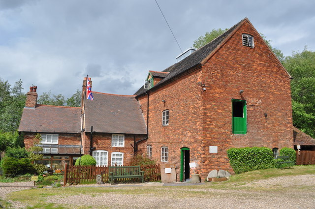
A preserved watermill near to Birmingham in Sutton Coldfield next to Newhall Valley Country Park.
The first mention was in 1586 with 'mill meadow', the first concrete evidence being 1585 when it was sold to William Gibbons. In the 1700s where were four small wheels powering four stones, this was later reduced to two powering two stones each. These were internal, later one of these (the existing one) was moved outside for more space. In 1895 the northern wheel was removed. A diesel was placed where the northern wheel was sited in 1949, this powered roller machines on the floor above. In 1963 E brook was diverted, effectively making the wheel useless. Until 1993 the mill ran, grinding corn to make animal feed. Even before it closed the preservation society had purchased and started restoration. Apart from a few modern safety features and wheel/stone restoration the mill is as closed. It is open, by donation and still runs most machinery. Friendly volunteers are always happy to chat. Link
 Map © Crown Copyright")
- Grid Square
- SP1394, 79 images (more nearby 🔍)
- Photographer
- Ashley Dace (more nearby)
- Date Taken
- Sunday, 8 May, 2011 (more nearby)
- Submitted
- Sunday, 8 May, 2011
- Subject Location
-
OSGB36:
 SP 132 944 [100m precision]
WGS84: 52:32.8699N 1:48.3887W - Camera Location
-
OSGB36: SP 131 944
- View Direction
- Northeast (about 45 degrees)