J3168 : The Mary Peters Track, Belfast (1)
taken 13 years ago, near to Drumbeg, Co Down, Northern Ireland
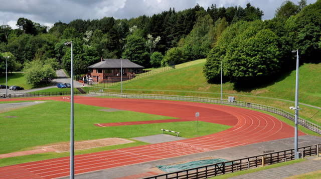
The Mary Peters Track, Belfast (1)
The north western end of the track.
Mary Peters Track and woodland, Belfast
An athletics track and 30 acres of coniferous woodland, reached from the Old Coach Road, off the Upper Malone Road, close to the Lagan towpath. Named after Dame Mary Peters, Olympic and Commonwealth games gold medallist, it opened in 1975 as part of Queens University. Now owned by Belfast City Council and managed by Athletics Northern Ireland Limited, in association with the council.
The track was refurbished in 2012/13. The works included a new eight lane International Association of Athletics Federations specification track, refurbishment of the field area and a new spectator stand.
![Creative Commons Licence [Some Rights Reserved]](https://s1.geograph.org.uk/img/somerights20.gif)
|
· Find out How to reuse this image ·
Share:
|
|||||
| Start a discussion on J3168 | Suggest an update to this image | Contact the contributor | |||
Loading map... (JavaScript required)
- Grid Square
- J3168, 87 images (more nearby
 )
)
- Photographer
- Albert Bridge (find more nearby)
- Date Taken
- Wednesday, 6 July, 2011 (more nearby)
- Submitted
- Wednesday, 6 July, 2011
- Geographical Context
- Subject Location
-
Irish:
 J 315 686 [100m precision]
WGS84: 54:32.9346N 5:58.0938W - Camera Location
-
Irish: J 316 686
- View Direction
- West-southwest (about 247 degrees)
Other Tags
Image classification(about):
Geograph
This page has been viewed about 216 times.
View this location:
KML (Google Earth) ·
Google Maps ·
Bing Maps ·
Geograph Coverage Map ·
More Links for this image
·
Bing Maps ·
Geograph Coverage Map ·
More Links for this image