J3474 : The Lagan Weir, Belfast (18)
taken 13 years ago, near to Belfast, Co Antrim, Northern Ireland
This is 1 of 32 images, with title starting with The Lagan weir, Belfast in this square
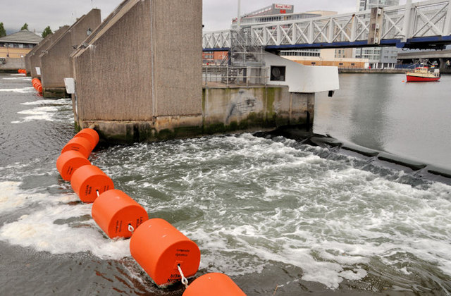
The Lagan Weir, Belfast (18)
Another in the series showing the weir at different states of the tide. Today is 48 minutes before high water, one day after the new moon with the weir gate raised.
For comparison this one J3474 : Dredging the River Lagan, Belfast - 2010/11 (41) (25 October 2010) shows the gate lowered, within a few minutes of high water, two days after the full moon.
This J3474 : The Lagan weir, Belfast (17) (15 May 2011) shows the gate raised, 18 minutes before low water, two days before the full moon.
The tide reaches its highest (and lowest) approximately two days after the full and new moons an effect known as a spring tide.
I wont even mention the relative distances of the Earth and the Moon!
![Creative Commons Licence [Some Rights Reserved]](https://s1.geograph.org.uk/img/somerights20.gif)
|
· Find out How to reuse this image ·
Share:
|
|||||
|
There are 4 posts in a
discussion on J3474 (preview on the left) |
Suggest an update to this image | Contact the contributor | |||
Loading map... (JavaScript required)
- Grid Square
- J3474, 4349 images (more nearby
 )
)
- Photographer
- Albert Bridge (find more nearby)
- Date Taken
- Sunday, 31 July, 2011 (more nearby)
- Submitted
- Sunday, 31 July, 2011
- Geographical Context
- Subject Location
-
Irish:
 J 344 745 [100m precision]
WGS84: 54:36.0604N 5:55.1803W - Camera Location
-
Irish: J 345 745
- View Direction
- West-northwest (about 292 degrees)
Other Tags
Image classification(about):
Geograph
This page has been viewed about 164 times.
View this location:
KML (Google Earth) ·
Google Maps ·
Bing Maps ·
Geograph Coverage Map ·
More Links for this image
·
Bing Maps ·
Geograph Coverage Map ·
More Links for this image