J3474 : Two "Seacats", Belfast
taken 22 years ago, near to Belfast, Co Antrim, Northern Ireland
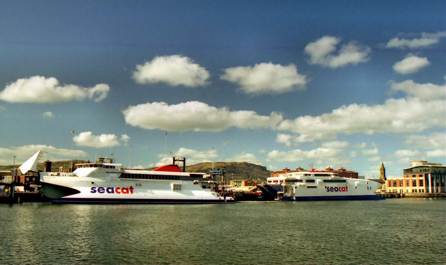
Two "Seacats", Belfast
A scene showing both berths at the Donegall Quay ferry terminal J3474 : Ferry terminal, Belfast in use. The Seacat Scotland J3474 : The "Seacat Scotland" at Belfast (left) is about to depart with the 16.00 sailing to Troon. The Seacat Rapide J3474 : The Seacat "Rapide" at Belfast had arrived with the 12.00 from Heysham. Both services have since been withdrawn and the terminal was later demolished J3474 : Former ferry terminal, Belfast (8).
City Quays, Belfast
A large-scale redevelopment of an area of disused harbour land (including the former Donegall Quay ferry terminal), on the seaward side of the cross-harbour bridges.
It includes three office buildings, a hotel and a multi-storey car park.
The third office building (CQ3) received planning permission on 5 February 2019 City Quays 3 - erection of 16 storey office accommodation (74 metres maximum height) comprising 23,976 sq metres of gross floorspace, associated access, public realm and other ancillary development. Lands approximately 100m north of M3 Cross Harbour Bridge and bounded by the River Lagan to the east Donegall Quay and Clarendon Dock to the north Corporation Square and Clarendon Quay to the west.
![Creative Commons Licence [Some Rights Reserved]](https://s1.geograph.org.uk/img/somerights20.gif)
|
· Find out How to reuse this image ·
Share:
|
|||||
|
There are 4 posts in a
discussion on J3474 (preview on the left) |
Suggest an update to this image | Contact the contributor | |||
Loading map... (JavaScript required)
- Grid Square
- J3474, 4349 images (more nearby
 )
)
- Photographer
- Albert Bridge (find more nearby)
- Date Taken
- Sunday, 14 April, 2002 (more nearby)
- Submitted
- Tuesday, 10 January, 2012
- Geographical Context
- Subject Location
-
Irish:
 J 344 748 [100m precision]
WGS84: 54:36.2440N 5:55.1988W - Camera Location
-
Irish: J 345 747
- View Direction
- Northwest (about 315 degrees)
Other Tags
Image classification(about):
Geograph
This page has been viewed about 275 times.
View this location:
KML (Google Earth) ·
Google Maps ·
Bing Maps ·
Geograph Coverage Map ·
More Links for this image
·
Bing Maps ·
Geograph Coverage Map ·
More Links for this image