J3774 : Earlswood Road development site, Belfast (5)
taken 12 years ago, 4 km E of Belfast, Co Antrim, Northern Ireland
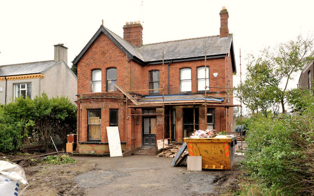
Earlswood Road development site, Belfast (5)
No 132 under renovation. This photograph appears as a matter of record only. I have no connection with the developer.
Earlswood Road development site, Belfast
Three large detached houses (nos 130-134) towards the Belmont Road end of the Earlswood Road. Described by the agents website as 3 detached houses of c. 2,100sqft each (in need of refurbishment) Excellent proximity to local amenities in the Belmont Area Suitable for the development of 6 large semi-detached (Subject to Planning). Note: the photographs submitted by me appear as a matter of record only. I have no known connection with the vendor or the agents. Please do not contact me about the development, prices, planning permission objections etc.
![Creative Commons Licence [Some Rights Reserved]](https://s1.geograph.org.uk/img/somerights20.gif)
|
· Find out How to reuse this image ·
Share:
|
|||||
| Start a discussion on J3774 | Suggest an update to this image | Contact the contributor | |||
Loading map... (JavaScript required)
- Grid Square
- J3774, 464 images (more nearby
 )
)
- Photographer
- Albert Bridge (find more nearby)
- Date Taken
- Saturday, 28 January, 2012 (more nearby)
- Submitted
- Saturday, 28 January, 2012
- Geographical Context
- Subject Location
-
Irish:
 J 375 744 [100m precision]
WGS84: 54:35.9459N 5:52.3170W - Camera Location
-
Irish: J 376 744
- View Direction
- West-southwest (about 247 degrees)
Other Tags
Image classification(about):
Geograph
This page has been viewed about 122 times.
View this location:
KML (Google Earth) ·
Google Maps ·
Bing Maps ·
Geograph Coverage Map ·
More Links for this image
·
Bing Maps ·
Geograph Coverage Map ·
More Links for this image