J1486 : Former "Riverside House", Antrim
taken 42 years ago, near to Antrim, Northern Ireland
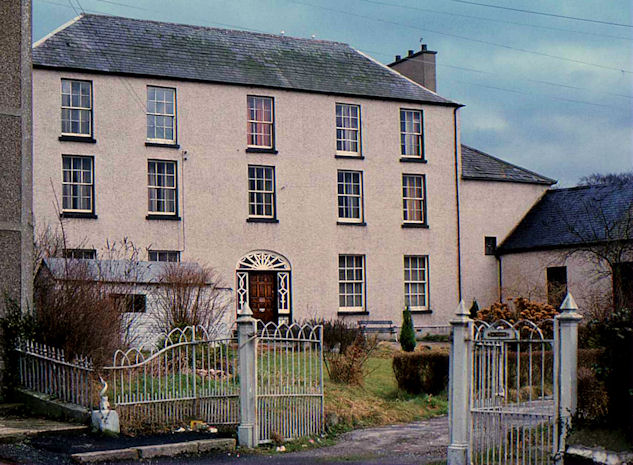
Former "Riverside House", Antrim
A house (alternatively Antrim House) at 11 Riverside, Antrim described on the Northern Ireland Buildings database as follows Demolished and replaced by a housing development. Described in the first survey in 1970 as "Early 19th century. A five bay, three-storey house with rendered walls and hipped slated roof. Each gable rises to a chimney stack. The entrance is recessed in an elliptical arched opening, the panelled door is flanked by sidelights, the fanlight has looped glazing. All windows are D/H with full glazing bars. A two-storey lean-to extension rises on the south gable with a one-storey building projecting from this to the south . . . . . Precise date of building not recorded but it appears on the OS map of 1832."
![Creative Commons Licence [Some Rights Reserved]](https://s1.geograph.org.uk/img/somerights20.gif)
|
· Find out How to reuse this image ·
Share:
|
|||||
| Start a discussion on J1486 | Suggest an update to this image | Contact the contributor | |||
Loading map... (JavaScript required)
- Grid Square
- J1486, 155 images (more nearby
 )
)
- Photographer
- Albert Bridge (find more nearby)
- Date Taken
- Saturday, 30 January, 1982 (more nearby)
- Submitted
- Tuesday, 10 April, 2012
- Geographical Context
- Subject Location
-
Irish:
 J 149 864 [100m precision]
WGS84: 54:42.7875N 6:13.0483W - Camera Location
-
Irish: J 149 864
- View Direction
- Southeast (about 135 degrees)
Other Tags
Image classification(about):
Geograph
This page has been viewed about 397 times.
View this location:
KML (Google Earth) ·
Google Maps ·
Bing Maps ·
Geograph Coverage Map ·
More Links for this image
·
Bing Maps ·
Geograph Coverage Map ·
More Links for this image