J4869 : Barn sign near Comber
taken 12 years ago, 3 km from Comber, Co Down, Northern Ireland
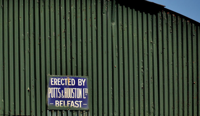
Barn sign near Comber
An enamel sign, on a barn beside the Ringcreevy Road J4869 : The Ringcreevy Road near Comber, showing that it was erected by Potts & Houston Ltd, iron and hardware merchants who had premises at 115 North Street and 90 Union Street, Belfast, in the early 20th century. The 1913 telephone directory gives a telephone number of Belfast 254.
Manhole covers, foundry products etc, Northern Ireland
A series of photographs showing manhole covers, fire hydrants, gratings, foundry products, foundry plaques and inscriptions etc, in Northern Ireland.
![Creative Commons Licence [Some Rights Reserved]](https://s1.geograph.org.uk/img/somerights20.gif)
|
· Find out How to reuse this image ·
Share:
|
|||||
| Start a discussion on J4869 | Suggest an update to this image | Contact the contributor | |||
Loading map... (JavaScript required)
- Grid Square
- J4869, 20 images (more nearby
 )
)
- Photographer
- Albert Bridge (find more nearby)
- Date Taken
- Monday, 16 April, 2012 (more nearby)
- Submitted
- Monday, 16 April, 2012
- Geographical Context
- Subject Location
-
Irish:
 J 485 692 [100m precision]
WGS84: 54:32.9913N 5:42.2785W - Camera Location
-
Irish: J 485 692
- View Direction
- North-northeast (about 22 degrees)
Other Tags
Image classification(about):
Supplemental image
This page has been viewed about 77 times.
View this location:
KML (Google Earth) ·
Google Maps ·
Bing Maps ·
Geograph Coverage Map ·
More Links for this image
·
Bing Maps ·
Geograph Coverage Map ·
More Links for this image