J3731 : The centre of the town of Newcastle from Curraghard Mountain
taken 12 years ago, near to Newcastle, Co Down, Northern Ireland
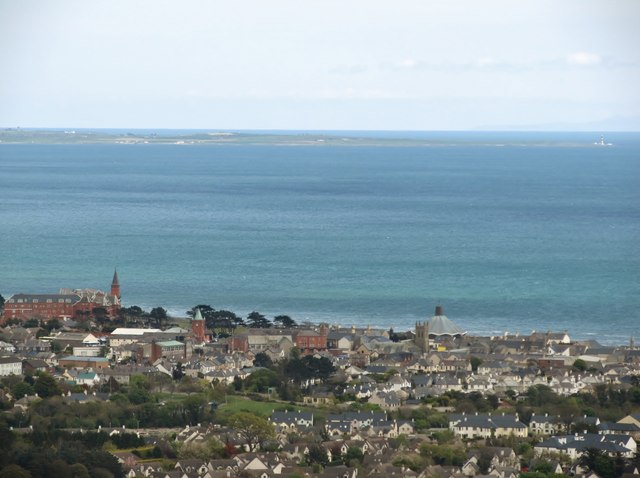
The centre of the town of Newcastle from Curraghard Mountain
Easily recognised land marks are from left to right: the Slieve Donard Hotel, the tower of Lidl store (formerly Newcastle Railway Station), the parasol roof of the Catholic church and the tower of the Presbyterian church. In the background right are St John's Point with its famous lighthouse and the hills of the Isle of Man.
![Creative Commons Licence [Some Rights Reserved]](https://s1.geograph.org.uk/img/somerights20.gif)
|
· Find out How to reuse this image ·
Share:
|
|||||
| Start a discussion on J3731 | Suggest an update to this image | Contact the contributor | |||
Loading map... (JavaScript required)
- Grid Square
- J3731, 1847 images (more nearby
 )
)
- Photographer
- Eric Jones (find more nearby)
- Date Taken
- Saturday, 5 May, 2012 (more nearby)
- Submitted
- Monday, 7 May, 2012
- Geographical Context
- Subject Location
-
Irish:
 J 376 315 [100m precision]
WGS84: 54:12.8427N 5:53.4439W - Camera Location
-
Irish: J 353 311
- View Direction
- EAST (about 90 degrees)
Image classification(about):
Supplemental image
This page has been viewed about 43 times.
View this location:
KML (Google Earth) ·
Google Maps ·
Bing Maps ·
Geograph Coverage Map ·
More Links for this image
·
Bing Maps ·
Geograph Coverage Map ·
More Links for this image