J3379 : Path, Belfast Castle (7)
taken 12 years ago, 3 km from Newtownabbey, Co Antrim, Northern Ireland
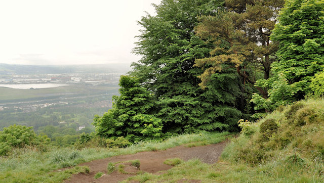
Path, Belfast Castle (7)
The path to the Cave Hill, as it emerges into the open, after its journey through a thick cover of deciduous trees. Suburban north Belfast and part of Belfast harbour can be seen on the left.
Belfast Castle, estate and the Cavehill Country Park, Belfast :: J3278
Belfast Castle J3279 : Belfast Castle was built between 1868 and 1870 for the Marquis of Donegall. The practice of Lanyon, Lynn and Lanyon were the architects but John Lanyon seems to have been the one who produced the design. It and the surrounding estate probably represent the swansong of the aristocracy in the face of the growth and ascendancy of the wealthy manufacturers, merchants and bankers emerging from expanding industrial Belfast. It was presented to the city in 1937.
The Cavehill Country Park adjoins the estate.
![Creative Commons Licence [Some Rights Reserved]](https://s1.geograph.org.uk/img/somerights20.gif)
|
· Find out How to reuse this image ·
Share:
|
|||||
| Start a discussion on J3379 | Suggest an update to this image | Contact the contributor | |||
Loading map... (JavaScript required)
- Grid Square
- J3379, 20 images (more nearby
 )
)
- Photographer
- Albert Bridge (find more nearby)
- Date Taken
- Wednesday, 6 June, 2012 (more nearby)
- Submitted
- Wednesday, 6 June, 2012
- Geographical Context
- Subject Location
-
Irish:
 J 330 797 [100m precision]
WGS84: 54:38.9117N 5:56.4105W - Camera Location
-
Irish: J 330 797
- View Direction
- East-southeast (about 112 degrees)
Other Tags
Image classification(about):
Geograph
This page has been viewed about 50 times.
View this location:
KML (Google Earth) ·
Google Maps ·
Bing Maps ·
Geograph Coverage Map ·
More Links for this image
·
Bing Maps ·
Geograph Coverage Map ·
More Links for this image