2012
SK0415 : Hill Pit, Brereton near Rugeley, Staffs
taken 12 years ago, near to Brereton, Staffordshire, England
This is 1 of 4 images, with title Hill Pit, Brereton near Rugeley, Staffs in this square
Hill Pit, Brereton near Rugeley, Staffs
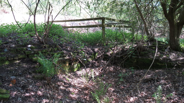
This is the site of the Main Shaft of Hill Pit, which operated between 1800 and 1850. It was located on Lord Pagett's lands just above The Glen on Colliery Road, Brereton. This photo clearly shows the remains of the brickwork that would have housed the winding gear and laoding area. Just behind this site are the remains of the tramway, which would have transported the coal down to the town of Rugeley and on to the Wharf where Rugeley Town railway station now stands.
 Map © Crown Copyright")
TIP: Click the map for more Large scale mapping
- Grid Square
- SK0415, 17 images (more nearby 🔍)
- Photographer
- Darren Sutton (more nearby)
- Date Taken
- Wednesday, 23 May, 2012 (more nearby)
- Submitted
- Friday, 8 June, 2012
- Subject Location
-
OSGB36:
 SK 04218 15532 [1m precision]
WGS84: 52:44.2443N 1:56.3380W - Camera Location
-
OSGB36: SK 0419 1551
- View Direction
- Northeast (about 45 degrees)