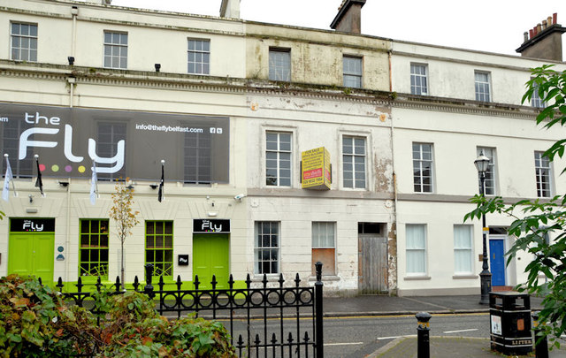
J3373 : No 7 Lower Crescent, Belfast (1)
taken 12 years ago, near to Belfast, Co Antrim, Northern Ireland
This is 1 of 2 images, with title starting with No 7 Lower Crescent, Belfast in this square
No 7 Lower Crescent, Belfast (1)
No 7 Lower Crescent is currently advertised for sale. The agents description includes the following: The subject property benefits from full planning permission (granted 11 September 2008) to convert the existing accommodation to a licensed premises, to include demolition of the rear return and rebuild with the retention of the existing facade onto Lower Crescent (Application No. /2007/2076/F).
The building, which seems to be in a poor state of repair, is listed Link (Archive Link ) . The list comments Relatively large three storey rendered town house, one of regency style terrace of eleven similar, (but not identical) properties built in 1852 and now converted to offices, flats and a public house.
This photograph appears as a matter of record only. I have no connection with any of the parties involved in the sale and express no views about the approval to demolish. See also J3373 : No 7 Lower Crescent, Belfast (2).
The building, which seems to be in a poor state of repair, is listed Link
This photograph appears as a matter of record only. I have no connection with any of the parties involved in the sale and express no views about the approval to demolish. See also J3373 : No 7 Lower Crescent, Belfast (2).
![Creative Commons Licence [Some Rights Reserved]](https://s1.geograph.org.uk/img/somerights20.gif)
|
· Find out How to reuse this image ·
Share:
|
|||||
|
There are 2 posts in a
discussion on J3373 (preview on the left) |
Suggest an update to this image | Contact the contributor | |||
Loading map... (JavaScript required)
- Grid Square
- J3373, 2776 images (more nearby
 )
)
- Photographer
- Albert Bridge (find more nearby)
- Date Taken
- Sunday, 14 October, 2012 (more nearby)
- Submitted
- Sunday, 14 October, 2012
- Geographical Context
- Subject Location
-
Irish:
 J 335 730 [100m precision]
WGS84: 54:35.2721N 5:56.0559W - Camera Location
-
Irish: J 335 730
- View Direction
- NORTH (about 0 degrees)
Other Tags
Image classification(about):
Geograph
This page has been viewed about 155 times.
View this location:
KML (Google Earth) ·
Google Maps ·
Bing Maps ·
Geograph Coverage Map ·
More Links for this image