2005
NS8237 : Dual carriageway at Alton Heights Junction
taken 18 years ago, near to New Trows, South Lanarkshire, Scotland
Dual carriageway at Alton Heights Junction
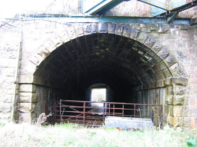
Alton Heights Junction, about 2km south of Lesmahagow, was a Caledonian Railway cross-roads. The first railway to arrive was the line from Motherwell to Coalburn, opened in 1856, principally to serve coal pits along its length. From 1883 a spur south-eastwards ran to Poneil Junction on the Lanark to Muirkirk line and in 1905 a line was built from Stonehouse through Lesmahagow town. It is the earliest line that is seen here. Immediately north of the junction it passed under the main Glasgow to Carlisle road at a very acute angle by this stone-lined tunnel-bridge; the blue girders sticking out above the portal, which at one time carried a pipeline, give the approximate alignment of the road. In due course the road was classified as the A74 and then widened as a dual carriageway. The angular concrete bridge carrying the new southbound carriageway can be seen at the far end of the tunnel. More recently the M74 motorway has replaced the old A74, which has been downgraded to a B road. Since this photograph was taken, the pipeline girders have also been removed (see photo NS8237 : The railway bridge under the B7078).
 Map © Crown Copyright")
TIP: Click the map for more Large scale mapping
- Grid Square
- NS8237, 12 images (more nearby 🔍)
- Photographer
- A-M-Jervis (more nearby)
- Date Taken
- Saturday, 12 November, 2005 (more nearby)
- Submitted
- Thursday, 3 January, 2013
- Subject Location
-
OSGB36:
 NS 8293 3789 [10m precision]
WGS84: 55:37.2276N 3:51.6323W - Camera Location
-
OSGB36: NS 8292 3785
- View Direction
- NORTH (about 0 degrees)