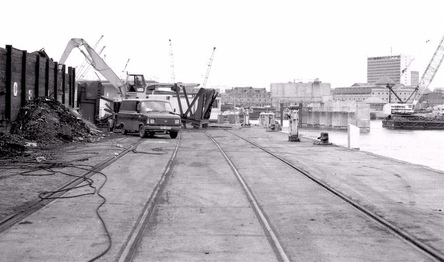
J3474 : Weir and cross-harbour bridges, Belfast (82)
taken 31 years ago, near to Belfast, Co Antrim, Northern Ireland
This is 1 of 42 images, with title starting with Weir and cross-harbour bridges, Belfast in this square
Weir and cross-harbour bridges, Belfast (82)
Work in progress on the removal of the old coal yards at Queens Quay. The M3 supports can be seen at middle right. For a then and now comparison see J3474 : The superyacht "Hampshire II", Belfast (June 2016).
Building the Lagan weir and cross-harbour bridges, Belfast
A collection of photographs showing the building of the Lagan weir and the cross-harbour road and railway bridges in the early 1990s. There are also some earlier shots of the pre-impounding River Lagan, of Donegall and Queens Quays, the Abercorn Basin and of the immediate area before demolition.
![Creative Commons Licence [Some Rights Reserved]](https://s1.geograph.org.uk/img/somerights20.gif)
|
· Find out How to reuse this image ·
Share:
|
|||||
|
There are 4 posts in a
discussion on J3474 (preview on the left) |
Suggest an update to this image | Contact the contributor | |||
Loading map... (JavaScript required)
- Grid Square
- J3474, 4349 images (more nearby
 )
)
- Photographer
- Albert Bridge (find more nearby)
- Date Taken
- Friday, 25 June, 1993 (more nearby)
- Submitted
- Saturday, 9 February, 2013
- Geographical Context
- Subject Location
-
Irish:
 J 345 747 [100m precision]
WGS84: 54:36.1775N 5:55.0908W - Camera Location
-
Irish: J 345 747
- View Direction
- South-southwest (about 202 degrees)
Other Tags
Image classification(about):
Geograph
This page has been viewed about 256 times.
View this location:
KML (Google Earth) ·
Google Maps ·
Bing Maps ·
Geograph Coverage Map ·
More Links for this image
·
Bing Maps ·
Geograph Coverage Map ·
More Links for this image