2003
NO7254 : Fishtown of Usan former salt boiling house and ice house
taken 21 years ago, near to Usan, Angus, Scotland
This is 1 of 7 images, with title starting with Fishtown of Usan in this square
Fishtown of Usan former salt boiling house and ice house
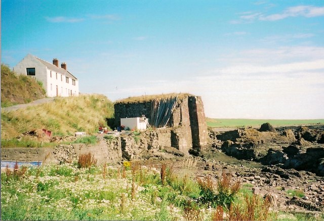
This photo shows the former salt boiling house and ice house at Fishtown of Usan in the old parish of Craig. Since the 15th January 1980, it has been designated a Grade C (S) listed building. This building is the sole survivor of three salt pans at Usan which were in use by 1798. Sea water was trapped in a rock basin and, particularly in summer, evaporation increased the salt concentration of the brine. A channel was cut through the rock to supply the pans with salt water at high tide. Sloops of 40 to 50 tons also used the channel to land coal. It took approximately 6 tons of coal to boil enough water to produce one ton of salt. Salt had been an expensive commodity but when the duty on it entering Scotland was repealed in January 1823, cheap rock salt flooded the market and all Scottish salt works became unprofitable and were shut down soon afterwards. This surviving salt pan or boiling house was converted into an ice house to store local salmon catches. At present, the building is used to weigh and grade locally caught wild salmon.
On the brae, above the former ice house, is the old salmon bothy. It has been converted into a house.
On the brae, above the former ice house, is the old salmon bothy. It has been converted into a house.
 Map © Crown Copyright")
TIP: Click the map for more Large scale mapping
- Grid Square
- NO7254, 96 images (more nearby 🔍)
- Photographer
- Adrian Diack (more nearby)
- Date Taken
- Saturday, 26 July, 2003 (more nearby)
- Submitted
- Saturday, 22 June, 2013
- Subject Location
-
OSGB36:
 NO 7258 5465 [10m precision]
WGS84: 56:40.9672N 2:26.9504W - Camera Location
-
OSGB36: NO 7256 5461
- View Direction
- North-northeast (about 22 degrees)