Geograph - photograph every grid square
2011
SD1678
: The Front Haverigg from River Lazy
taken
13 years ago
,
near
to
Haverigg
, Cumbria, England
This is 1 of
2 images, with title starting with The Front
in this square
The Front Haverigg from River Lazy
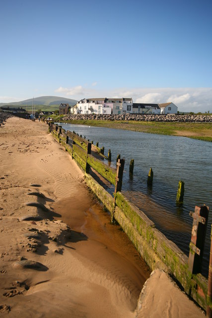
The properties at The Front, Haverigg are seen from the sandy west bank of the River Lazy (also known as Haverigg Pool) at low tide. In the distance is Black Combe.
© Copyright
Andy Deacon
and licensed for
reuse
under this
Creative Commons Licence
.
Licensing
Download
More Sizes
Share...
Share this photo via Twitter
Share this photo via Facebook
Share this photo via Pinterest
Share this photo via Flipboard
Share this photo via email/e-card
Grab a Stamped/Watermarked Image
Mark
👍🏻
Like Image
👍🏻
Like Description
Update Information
Contact Contributor
Geographical Context:
Coastal
Rivers, Streams, Drainage
Docks, Harbours
Estuary, Marine
County:
Cumbria
Near:
Millom
Sky:
Blue
Long Distance Path:
Cumbria Coastal Way
Image Buckets
?
:
Wideangle
other tags:
River
Sea Defences
Sand
Sandy
Sandy Beach
Harbour
Village
Dry Weather
Rotting Groyne
Private House
Seafront Housing
Cumbria Coastal Way
Towns and Villages in Cumbria
Click a tag, to view other nearby images.
This photo is linked from:
Automatic Clusters
: ·
Low Tide [8]
·
River Lazy [7]
·
Haverigg Pool at Low Tide [5]
·
River Lazy also Known as Haverigg Pool [3]
·
TIP: Click the map for more Large scale mapping
Grid Square
SD1678
, 64 images (
more nearby
🔍
)
Photographer
Andy Deacon
(
more nearby
)
Date Taken
Wednesday, 25 May, 2011 (
more nearby
)
Submitted
Monday, 12 August, 2013
Subject Location
OSGB36:
SD 1615 7862
[10m precision]
WGS84:
54:11.7873N
3:17.2043W
Camera Location
OSGB36:
SD 1617 7850
View Direction
NORTH (about 0 degrees)
NW
N
NE
W
Go
E
SW
S
SE
Discuss SD1678
View this location on ...
Geograph Coverage Map (includes OSM etc)
Geograph Links Page
Open in Google Maps
Navigate to location with Google Maps
Open in Google Earth Pro
Open in Google Earth for Web
Open in Bing Maps
Navigate with Google Maps
Lookup nearest Postcode
Image classification
(about)
: Geograph
This page has been
viewed
about
108
times
☰
Home
View
Search
Marked Images
Maps
Browser
Explore
Showcase
New Images
Collections
Interact
Games
Discussions
Blog
Contributors
Submit
Statistics
Leaderboards
General
FAQ
Help Pages
Sitemap
Contact Us
Support Us
sponsored by
🔍
What to search:
Photos
Enter keywords or a location/postcode to search nearby images
Photos near SD1678
Enter a Grid Reference
Placenames
Collections
Website Pages
Everything
Others:
Advanced Search
|
Image Browser
Or:
Coverage Map
|
Searchable Map
You are not logged in
login
|
register