J3374 : Union Street, Belfast (2013-1)
taken 11 years ago, near to Belfast, Co Antrim, Northern Ireland
This is 1 of 4 images, with title starting with Union Street, Belfast in this square
Union Street, Belfast (2013-1)
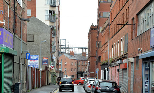
Union Street, looking across North Street, towards Kent Street. The structural steelwork for this building J3374 : Building, Belfast (2013-1) can be seen in the middle background.
Union Street, Belfast
Union Street runs from Donegall Street to North Street. It seems to have been built around 1806/07 and, for many years, was mixed residential and commercial. The 1843 street directory shows a wide variety of residents and businesses. They included publicans, pawnbrokers, a feather merchant, a loom maker and two lodging houses. Much of the area (2013) is in need of attention and/or investment.
![Creative Commons Licence [Some Rights Reserved]](https://s1.geograph.org.uk/img/somerights20.gif)
|
· Find out How to reuse this image ·
Share:
|
|||||
|
There is 1 post in a
discussion on J3374 (preview on the left) |
Suggest an update to this image | Contact the contributor | |||
Loading map... (JavaScript required)
- Grid Square
- J3374, 3632 images (more nearby
 )
)
- Photographer
- Albert Bridge (find more nearby)
- Date Taken
- Thursday, 22 August, 2013 (more nearby)
- Submitted
- Thursday, 22 August, 2013
- Geographical Context
- Place (from Tags)
- Subject Location
-
Irish:
 J 335 747 [100m precision]
WGS84: 54:36.1826N 5:56.0191W - Camera Location
-
Irish: J 335 746
- View Direction
- North-northeast (about 22 degrees)
Other Tags
Image classification(about):
Geograph
This page has been viewed about 111 times.
View this location:
KML (Google Earth) ·
Google Maps ·
Bing Maps ·
Geograph Coverage Map ·
More Links for this image
·
Bing Maps ·
Geograph Coverage Map ·
More Links for this image