J3575 : The "Pacific Osprey", Belfast (1)
taken 11 years ago, near to Belfast, Co Antrim, Northern Ireland
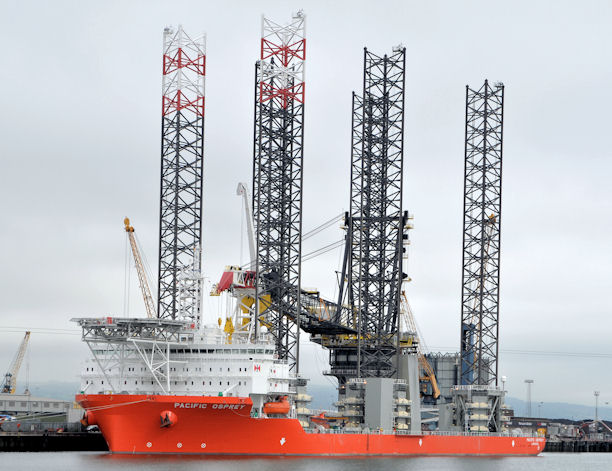
The Pacific Osprey is a purpose-built (delivered February 2013) wind farm installation vessel owned by Swire Blue Ocean Link
. The vessels dimensions are length overall 160.9 m, breadth 49 m and a maximum draft 6 m with accommodation for 111 people. Onboard facilities include single cabins, fitness rooms, two cinemas and (for use when the vessel is in port) a pool room. This animation Link
Wharf at the Victoria Channel, Belfast docks. The wharf was constructed 1956-62 by Charles Brand & Son, to provide a total lineal quayage of 580 metres; this was further extended by an additional 250 metres which was completed in 2009. Stormont Wharf is now one of the longest deep water quays in Ireland.
This collection shows some of the parts and the vessels used to transport them at sea.
![Creative Commons Licence [Some Rights Reserved]](https://s1.geograph.org.uk/img/somerights20.gif)
|
· Find out How to reuse this image ·
Share:
|
|||||
| Start a discussion on J3575 | Suggest an update to this image | Contact the contributor | |||
- Grid Square
- J3575, 1038 images (more nearby
 )
)
- Photographer
- Albert Bridge (find more nearby)
- Date Taken
- Thursday, 12 September, 2013 (more nearby)
- Submitted
- Thursday, 12 September, 2013
- Geographical Context
- Place (from Tags)
- Subject Location
-
Irish:
 J 351 759 [100m precision]
WGS84: 54:36.8304N 5:54.5001W - Camera Location
-
Irish: J 352 756
- View Direction
- NORTH (about 0 degrees)
Other Tags