2010
NS3779 : Remains of a square structure
taken 13 years ago, near to Alexandria, West Dunbartonshire, Scotland
This is 1 of 5 images, with title Remains of a square structure in this square
Remains of a square structure
See NS3779 : Remains of a square structure for more information.
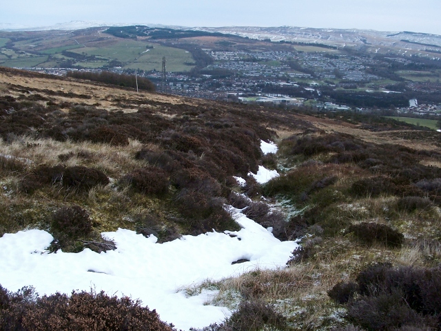
The picture shows the south-western corner of the structure, in the foreground, and the southern edge leading away from it. Though the day was dull, the snow serves to make the course of the surrounding ditch more readily apparent.
NS3779 : Millburn Muir transmitter can be seen in the background.
The picture shows the south-western corner of the structure, in the foreground, and the southern edge leading away from it. Though the day was dull, the snow serves to make the course of the surrounding ditch more readily apparent.
NS3779 : Millburn Muir transmitter can be seen in the background.
Square enclosure near Carman Hill
A square enclosure, 45 metres to a side, is bounded by a low ridge surrounded by a ditch. It is of uncertain age, but it is centred on a point 200 metres to the north-east of the inner enclosure of Carman Hill-Fort (see Link for the fort). Although there is higher ground on three sides, the location commands a view of the Vale of Leven, the Kilpatrick Hills, and Dumbarton Rock. See Link
for an annotated satellite view, showing the square enclosure to the NNE of the hill-fort.
(The enclosure was found, on satellite imagery, by Geograph contributor Stan Campbell Link who mentioned it to me; I later visited the site, and sent a report on his behalf to WoSAS, to ensure that the find would be properly credited to him.)
 Map © Crown Copyright")
TIP: Click the map for more Large scale mapping
- Grid Square
- NS3779, 116 images (more nearby 🔍)
- Photographer
- Lairich Rig (more nearby)
- Date Taken
- Friday, 17 December, 2010 (more nearby)
- Submitted
- Thursday, 31 October, 2013
- Subject Location
-
OSGB36:
 NS 3727 7961 [10m precision]
WGS84: 55:58.9077N 4:36.5886W - Camera Location
-
OSGB36: NS 3726 7961
- View Direction
- East-southeast (about 112 degrees)