D0345 : Ballintoy harbour
taken 17 years ago, near to Ballintoy, Co Antrim, Northern Ireland
This is 1 of 55 images, with title Ballintoy harbour in this square
Ballintoy harbour
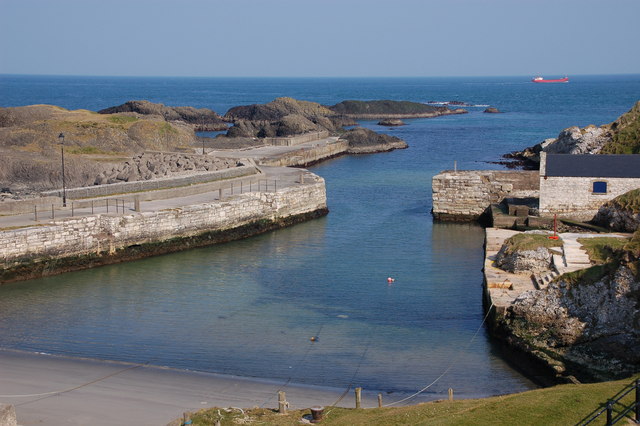
Ballintoy harbour was used for the export of limestone the photo being taken from the top of the old kilns. It is now used only by a few small boats. Ships were much smaller in the 19th century and the red coaster passing (top right) would be in serious difficulty if her master decided to enter!
![Creative Commons Licence [Some Rights Reserved]](https://s1.geograph.org.uk/img/somerights20.gif)
|
· Find out How to reuse this image ·
Share:
|
|||||
| Start a discussion on D0345 | Suggest an update to this image | Contact the contributor | |||
Loading map... (JavaScript required)
- Grid Square
- D0345, 405 images (more nearby
 )
)
- Photographer
- Albert Bridge (find more nearby)
- Date Taken
- Saturday, 31 March, 2007 (more nearby)
- Submitted
- Saturday, 31 March, 2007
- Category
- Harbour (more nearby)
- Subject Location
-
Irish:
 D 03 45 [1000m precision]
WGS84: 55:14.7378N 6:22.4066W - Camera Location
-
Irish: D 03 45
- View Direction
- NORTH (about 0 degrees)
Image classification(about):
Geograph (Fourth Visitor for D0345)
This page has been viewed about 81 times.
View this location:
KML (Google Earth) ·
Google Maps ·
Bing Maps ·
Geograph Coverage Map ·
More Links for this image
·
Bing Maps ·
Geograph Coverage Map ·
More Links for this image