J4780 : Direction signs near Bangor
taken 10 years ago, near to Crawfordsburn, Co Down, Northern Ireland
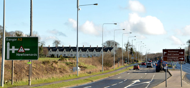
Direction signs near Bangor
Two directions sign on the Belfast Road. The one on the left shows the route to Bangor via the main road. The height restriction refers to this bridge J4779 : Private bridge, Ballysallagh Road near Bangor on the Ballysallagh Road. The brown one (right) is to facilities on the Clandeboye estate.
Road signs and markings, Northern Ireland
A collection of photographs showing road signs and marking in their context. It exists as a matter of record only, has no connection with any official body and does not claim to be a definitive or legally-binding guide. The official version is the Highway Code for Northern Ireland.
No breach of Crown copyright intended. I believe that my submissions are in accordance with the terms of the Open Government Licence for public sector information Link
![Creative Commons Licence [Some Rights Reserved]](https://s1.geograph.org.uk/img/somerights20.gif)
|
· Find out How to reuse this image ·
Share:
|
|||||
| Start a discussion on J4780 | Suggest an update to this image | Contact the contributor | |||
Loading map... (JavaScript required)
- Grid Square
- J4780, 12 images (more nearby
 )
)
- Photographer
- Albert Bridge (find more nearby)
- Date Taken
- Monday, 24 February, 2014 (more nearby)
- Submitted
- Monday, 24 February, 2014
- Geographical Context
- Subject Location
-
Irish:
 J 470 800 [100m precision]
WGS84: 54:38.8072N 5:43.3546W - Camera Location
-
Irish: J 470 800
- View Direction
- EAST (about 90 degrees)
Other Tags
Image classification(about):
Geograph
This page has been viewed about 80 times.
View this location:
KML (Google Earth) ·
Google Maps ·
Bing Maps ·
Geograph Coverage Map ·
More Links for this image