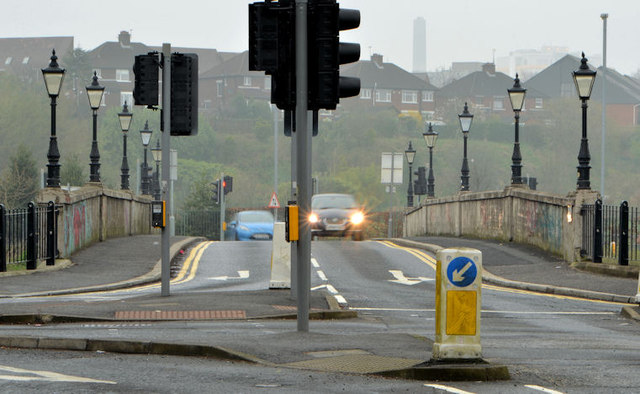
J3471 : The King's Bridge, Belfast - April 2014(1)
taken 10 years ago, near to Belfast, Co Antrim, Northern Ireland

The King’s Bridge, across the River Lagan, connecting the Stranmillis and Annadale Embankments, opened in 1910 and is believed to be the first reinforced concrete road bridge in Ireland. It is subject to a weight restriction of 7.5 tonnes.
For more information about the bridge see this link Link.
The effects (mainly smog, dust settled on vehicles and difficulties for asthmatics) of the wind-carried dust from the Sahara Desert have made news in the last few days (April 2014). The worst has been in parts of England although there were media reports of the material in NI. Today’s “Independent” recorded “Saharan dust and record levels of air pollution will continue to plague the UK today, leading experts to advise schools to keep children indoors in the worst affected parts of England. A perfect storm of dust from the Sahara, emissions from the Continent, low south-easterly winds and domestic pollution has caused air quality to plummet while pollution levels soar in England and Wales. The smog-like conditions are forecast to remain until Friday [4 April 2014]”. The dust is explained in this link Link
.
The photographs submitted by me show what might be Sahara dust. I am not a scientist or meteorologist and it’s quite possible that I am completely wrong.
- Grid Square
- J3471, 273 images (more nearby
 )
)
- Photographer
- Albert Bridge (find more nearby)
- Date Taken
- Thursday, 3 April, 2014 (more nearby)
- Submitted
- Thursday, 3 April, 2014
- Geographical Context
- Place (from Tags)
- Subject Location
-
Irish:
 J 340 718 [100m precision]
WGS84: 54:34.6191N 5:55.6992W - Camera Location
-
Irish:
 J 340 717
 - View Direction
- West-northwest (about 292 degrees)
![Creative Commons Licence [Some Rights Reserved]](https://s1.geograph.org.uk/img/somerights20.gif)
