J3274 : Lawnbrook Avenue, Belfast - April 2014(1)
taken 10 years ago, near to Belfast, Co Antrim, Northern Ireland
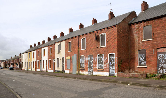
Lawnbrook Avenue, running from the Shankill Road to Cupar Street was a street of 102 houses built sometime between 1880 and 1890. The eastern/south eastern side has been redeveloped. Some of the other side has been redeveloped but still (April 2014) includes many of the original terrace houses now vacant, boarded-up and partly derelict. Some of the vacant houses no longer display numbers.
Brookmount Street was built circa 1891/1900. Demolition of it and the neighbouring Glenwood Street began during September 2014. Media reports suggest that there are no immediate plans to build replacement housing.
The photographs submitted by me appear as a neutral matter of geographical and historical record only. I have no connection with any campaign for redevelopment of the streets.
![Creative Commons Licence [Some Rights Reserved]](https://s1.geograph.org.uk/img/somerights20.gif)
|
· Find out How to reuse this image ·
Share:
|
|||||
|
There are 2 posts in a
discussion on J3274 (preview on the left) |
Suggest an update to this image | Contact the contributor | |||
- Grid Square
- J3274, 289 images (more nearby
 )
)
- Photographer
- Albert Bridge (find more nearby)
- Date Taken
- Monday, 7 April, 2014 (more nearby)
- Submitted
- Monday, 7 April, 2014
- Geographical Context
- Place (from Tags)
- Subject Location
-
Irish:
 J 321 747 [100m precision]
WGS84: 54:36.2058N 5:57.3830W - Camera Location
-
Irish: J 321 747
- View Direction
- Southwest (about 225 degrees)
Other Tags