J4167 : Staggered crossroads advance direction sign, Moneyreagh
taken 10 years ago, near to Moneyreagh, Co Down, Northern Ireland
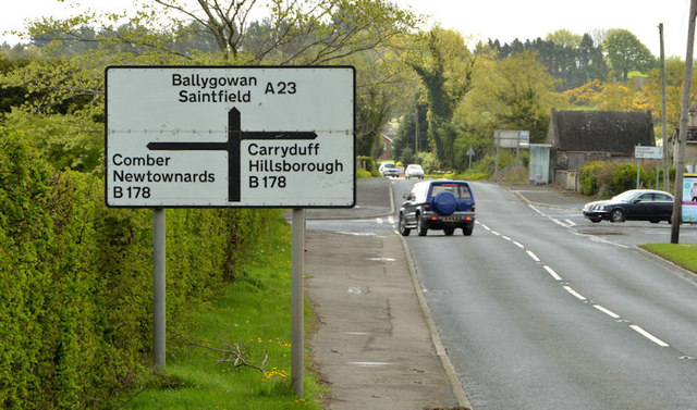
Staggered crossroads advance direction sign, Moneyreagh
The southbound advance direction sign, at a staggered crossroads, where the Hillsborough Comber Road J4467 : The Hillsborough Road, Comber (1) and J4467 : Direction signs, Comber crosses the Belfast Ballygowan road. The white background is used where the road, although classified A, is a non-primary one. J4167 : Crossroads, Moneyreagh (October 2017) shows the view from the Carryduff side.
Road signs and markings, Northern Ireland
A collection of photographs showing road signs and marking in their context. It exists as a matter of record only, has no connection with any official body and does not claim to be a definitive or legally-binding guide. The official version is the Highway Code for Northern Ireland.
No breach of Crown copyright intended. I believe that my submissions are in accordance with the terms of the Open Government Licence for public sector information Link
![Creative Commons Licence [Some Rights Reserved]](https://s1.geograph.org.uk/img/somerights20.gif)
|
· Find out How to reuse this image ·
Share:
|
|||||
| Start a discussion on J4167 | Suggest an update to this image | Contact the contributor | |||
Loading map... (JavaScript required)
- Grid Square
- J4167, 6 images (more nearby
 )
)
- Photographer
- Albert Bridge (find more nearby)
- Date Taken
- Saturday, 26 April, 2014 (more nearby)
- Submitted
- Saturday, 26 April, 2014
- Geographical Context
- Place (from Tags)
- Primary Subject of Photo
- Subject Location
-
Irish:
 J 410 671 [100m precision]
WGS84: 54:31.9684N 5:49.3537W - Camera Location
-
Irish: J 410 671
- View Direction
- South-southeast (about 157 degrees)
Other Tags
Image classification(about):
Geograph (Second Visitor for J4167)
· First in 5 Years (TPoint) (about)
This page has been viewed about 117 times.
View this location:
KML (Google Earth) ·
Google Maps ·
Bing Maps ·
Geograph Coverage Map ·
More Links for this image