J2664 : "The Tavern", Lisburn (May 2014)
taken 10 years ago, near to Lisburn, Co Antrim, Northern Ireland
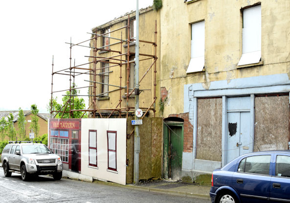
"The Tavern", Lisburn (May 2014)
See J2664 : "The Tavern", Lisburn (2013-1) (May 2013). The Tavern, Bridge Street, still standing but possibly in danger from the vibrations of a passing moped. This series started in February 2007 J2664 : The Tavern, Lisburn (2007) making the building a mere apprentice when compared with Queens Parade, Bangor Link and Lower Garfield Street, Belfast J3374 : Lower Garfield Street, Belfast (1997). The building on the right has lost its disguise. Continue to J2664 : "The Tavern", Lisburn (September 2014).
Bridge Street, Lisburn
Bridge Street runs from Market Square to the Queens Road and the Union Bridge. The northern side is occupied shops. The southern side is occupied shops, vacant buildings and vacant ground.
![Creative Commons Licence [Some Rights Reserved]](https://s1.geograph.org.uk/img/somerights20.gif)
|
· Find out How to reuse this image ·
Share:
|
|||||
| Start a discussion on J2664 | Suggest an update to this image | Contact the contributor | |||
Loading map... (JavaScript required)
- Grid Square
- J2664, 512 images (more nearby
 )
)
- Photographer
- Albert Bridge (find more nearby)
- Date Taken
- Sunday, 18 May, 2014 (more nearby)
- Submitted
- Sunday, 18 May, 2014
- Geographical Context
- Place (from Tags)
- Subject Location
-
Irish:
 J 269 642 [100m precision]
WGS84: 54:30.6297N 6:2.4887W - Camera Location
-
Irish: J 268 642
- View Direction
- Southeast (about 135 degrees)
Other Tags
Image classification(about):
Geograph
This page has been viewed about 124 times.
View this location:
KML (Google Earth) ·
Google Maps ·
Bing Maps ·
Geograph Coverage Map ·
More Links for this image