H6017 : The ruins of Dartrey Castle which overlook Inner Lough and Black Island
taken 10 years ago, near to Dartrey, Co Monaghan, Ireland
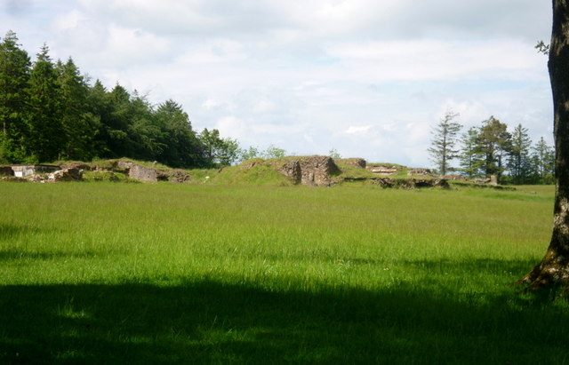
The ruins of Dartrey Castle which overlook Inner Lough and Black Island
The Dawson family, who owned the Dartrey estate, built this mansion, known locally as Dartrey Castle (designed by the Scottish architect William Burn) in 1846 Link (Archive Link )
This Gothic-style Elizabethan Revival mansion lasted only a century. When the beautiful Dartrey estate was sold to forestry in about 1950, this great building was demolished and sold brick by brick. Further on the Dartrey estate Link
This Gothic-style Elizabethan Revival mansion lasted only a century. When the beautiful Dartrey estate was sold to forestry in about 1950, this great building was demolished and sold brick by brick. Further on the Dartrey estate Link
![Creative Commons Licence [Some Rights Reserved]](https://s1.geograph.org.uk/img/somerights20.gif)
|
· Find out How to reuse this image ·
Share:
|
|||||
| Start a discussion on H6017 | Suggest an update to this image | Contact the contributor | |||
Loading map... (JavaScript required)
- Grid Square
- H6017, 15 images (more nearby
 )
)
- Photographer
- D Gore (find more nearby)
- Date Taken
- Saturday, 31 May, 2014 (more nearby)
- Submitted
- Friday, 13 June, 2014
- Geographical Context
- Place (from Tags)
- Primary Subject of Photo
- Subject Location
-
Irish:
 H 608 173 [100m precision]
WGS84: 54:6.0761N 7:4.2801W - Camera Location
-
Irish: H 607 171
- View Direction
- North-northeast (about 22 degrees)
Other Tags
Image classification(about):
Geograph
This page has been viewed about 311 times.
View this location:
KML (Google Earth) ·
Google Maps ·
Bing Maps ·
Geograph Coverage Map ·
More Links for this image