2014
TF0307 : Ironmonger Street and the Church of St Michael the Greater, Stamford
taken 10 years ago, near to Stamford, Lincolnshire, England
This is 1 of 9 images, with title starting with Ironmonger Street in this square
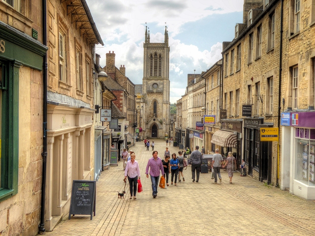
Ironmonger Street and the Church of St Michael the Greater, Stamford
Looking down Ironmonger Street towards the tower of (the former) St Michael's Church.
The Church of St Michael the Greater is a late-Georgian Gothic church which stands on the south side of Stamford High Street on the site of an earlier, Medieval predecessor. It is a grade II listed building (English Heritage Building ID: 193558 Link British Listed Buildings). It was called St Michael the Greater to distinguish it from another church, St Michael in Cornstall, situated elsewhere in Stamford.
The original mediæval church collapsed in 1832 and the current building, designed by John Brown of Norwich was built in Ketton stone over 1835-6 in Early English style (based on the style of the Lady Chapel of Salisbury Cathedral)
The church was declared redundant in 1974 and after some years when several options, including demolition, were considered it was transformed into shops in 1982
Link Wikipedia page about St Michaels Church
The Church of St Michael the Greater is a late-Georgian Gothic church which stands on the south side of Stamford High Street on the site of an earlier, Medieval predecessor. It is a grade II listed building (English Heritage Building ID: 193558 Link
The original mediæval church collapsed in 1832 and the current building, designed by John Brown of Norwich was built in Ketton stone over 1835-6 in Early English style (based on the style of the Lady Chapel of Salisbury Cathedral)
The church was declared redundant in 1974 and after some years when several options, including demolition, were considered it was transformed into shops in 1982
Link
 Map © Crown Copyright")
TIP: Click the map for more Large scale mapping
- Grid Square
- TF0307, 1081 images (more nearby 🔍)
- Photographer
- David Dixon (more nearby)
- Date Taken
- Wednesday, 6 August, 2014 (more nearby)
- Submitted
- Tuesday, 12 August, 2014
- Subject Location
-
OSGB36:
 TF 0304 0718 [10m precision]
WGS84: 52:39.1543N 0:28.6950W - Camera Location
-
OSGB36: TF 0300 0725
- View Direction
- South-southeast (about 157 degrees)