D3115 : St Patrick's graveyard and former friary Glenarm
taken 18 years ago, near to Glenarm, Co Antrim, Northern Ireland
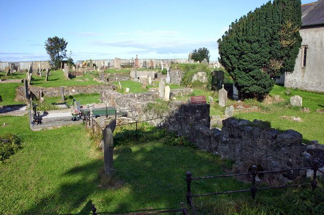
St Patrick's graveyard and former friary Glenarm
Robert Bissett donated land after Pope Eugenius VI authorised the archdeacon of Connor to establish a Franciscan Third Order Regular friary in 1445 that was finally established in 1465. What remains of the friary is not easy to interpret and archaeological investigations in the summer of 2005 revealed that the friary was larger than previously thought, with evidence of outbuildings uncovered beneath the vestry. The earliest inscription on the grave stones dates from 1641 and there are at least two other memorials bearing dates prior to 1700. An act of parliament of 1698 banned burials within the confines of a dissolved monastery but this ruling was ignored. Permission to build the 'new' church was granted in December 1759 but it was not built for some years and a parliamentary report of 1768 noted a very good new church in Glenarm but the church was finally consecrated in 1769. Work on the new church appears to have started in early 1763, the majority of it undertaken by a stonemason named William McBride. Some documents mistakenly state that the spire was a later addition.
![Creative Commons Licence [Some Rights Reserved]](https://s1.geograph.org.uk/img/somerights20.gif)
|
· Find out How to reuse this image ·
Share:
|
|||||
| Start a discussion on D3115 | Suggest an update to this image | Contact the contributor | |||
Loading map... (JavaScript required)
- Grid Square
- D3115, 141 images (more nearby
 )
)
- Photographer
- Jo and Steve Turner (find more nearby)
- Date Taken
- Thursday, 7 September, 2006 (more nearby)
- Submitted
- Sunday, 17 August, 2014
- Geographical Context
- Primary Subject of Photo
- Subject Location
-
Irish:
 D 3102 1533 [10m precision]
WGS84: 54:58.0965N 5:57.2949W - Camera Location
-
Irish: D 3101 1531
- View Direction
- North-northeast (about 22 degrees)
Image classification(about):
Geograph
This page has been viewed about 30 times.
View this location:
KML (Google Earth) ·
Google Maps ·
Bing Maps ·
Geograph Coverage Map ·
More Links for this image
·
Bing Maps ·
Geograph Coverage Map ·
More Links for this image