2014
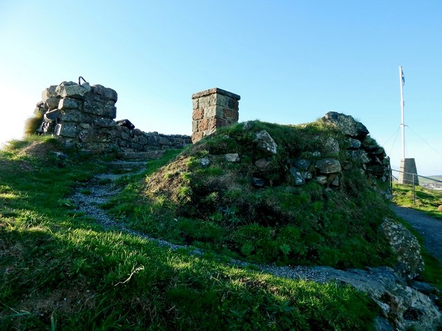
NS3974 : Dumbarton Castle: remains of a circular structure
taken 9 years ago, near to Dumbarton, West Dunbartonshire, Scotland
This is 1 of 3 images, with title Dumbarton Castle: remains of a circular structure in this square
Dumbarton Castle: remains of a circular structure
The photograph shows part of the top of White Tower Crag (NS3974 : Dumbarton Castle: White Tower Crag), the western peak of Dumbarton Rock. On the right are a trig point (NS3974 : Trig point on Dumbarton Rock) and flagstaff (NS3974 : Dumbarton Rock and Castle).
Near the centre of the picture is a toposcope (NS3974 : Dumbarton Rock: White Tower Crag). It is easy to overlook the section of old circular wall that makes up the right foreground of the present photograph. It is shown from the other side in NS3974 : Dumbarton Castle: remains of a circular structure.
In old books, and in the Ordnance Survey Name Books, it is referred to as the remains of a Roman Pharos (lighthouse), but, as explained below, this explanation is founded only upon tradition, and not upon any reliable ancient accounts.
However, the relevant passages are not without interest, if only as historical curiosities. One of them is the following, taken from Thomas Pennant's "A Tour in Scotland in 1769", published in 1771:
"The castle is seated a little South of the town on a two-headed rock of a stupendous height, rising in a strange manner out of the sands, and totally detached from every thing else; is bounded on one side by the Clyde, on the other by the Levin. On one of the summits are the remains of an old light-house, which some suppose to have been a Roman Pharos; on the other, the powder magazine: in the hollow is a large well of water fourteen feet deep."
(The magazine mentioned there is shown in NS4074 : Dumbarton Rock: the Magazine. As for the well, its drying up during the Viking siege of 870 see the article linked from the end-note led to the sacking of the Rock, and its subsequent abandonment, and to the re-location of the Britons' seat of power further up the Clyde.)
The idea that these are the remains of a Roman Pharos is expressed once again in Robert Stuart's "Caledonia Romana" (1845). The relevant passage from that book is as follows:
"Dumbarton Castle, the Alcluith, or Alcluyd, of the aboriginal Britons, and the Dunbriton of their Scoto-Irish descendants, was unquestionably a Roman military station; and it would seem that a provincial town had existed under its protection during some period of the Roman government. The transports and war-galleys, which visited the Clyde from the coasts of England and from other quarters, came to anchor, it is believed, under the shadow of its bi-furcated rock, on whose western summit burned, we are told, a beacon light a Roman Pharos to direct the ancient mariner to the haven below. This is the only station which existed beyond the wall on the western side of the Island. It is not mentioned by Ptolemy, but is to be found in the Chorography of Richard, under the name of Theodosia, and in the ranks of a municipal town."
One footnote to that passage refers to Pennant's Tour, already quoted, while the other states that "Richard, in his Map, places Theodosia at the efflux of the Leven from Lochlomond, near the site of Balloch Castle ...".
A little later, Stuart says more on the subject:
"Tradition has long pointed to the foundation of a circular building, still to be seen near the principal flag-staff at Dumbarton Castle, as the remains of a Roman lighthouse or watch-tower [a footnote here refers the reader to Gough's Camden, III 352]; but nothing beyond tradition can be referred to as evidence on the subject; there, however, are the firmly cemented stones, which have certainly formed a portion of some such structure, by whomsoever it was erected; and, if not Roman, its builders would seem to have, at all events, possessed not a little of Roman skill in preparing the particular mortar made use of in its construction".
Stuart frankly acknowledges that the idea of the ruin being that of a Roman lighthouse is based on tradition alone. However, there are some clues in the above passages that indicate that he had, in part, based his ideas on "De Situ Britanniae", a work that was supposedly written by the monk Richard of Cirencester (he is the "Richard" who is mentioned by Stuart in one of the passages just quoted), and which was received enthusiastically by historians, not least because it appeared to answer many puzzling questions.
In fact, "De Situ Britanniae" was a forgery, the work of Charles Bertram. Unfortunately, it was accepted as genuine for a very long time, long enough for its ideas to infect many subsequent historical writings, as they do down to this day: see Link (in one of my Geograph articles), where I discuss this topic in more detail.
For example, in the passages from "Caledonia Romana" quoted above, Robert Stuart refers twice (once in his main text, and once in a footnote) to Theodosia, which was a supposed Roman naval base at Dumbarton. However, Theodosia is a fiction; it was first mentioned by Bertram in his "De Situ Britanniae", and was simply an invention on his part.
The old circular ruin is also mentioned by Dorothy Wordsworth, who saw it when she visited the Rock and its castle in 1803, in company with her brother William and the poet Coleridge. She writes that:
"The soldier who was our guide told us that an old ruin which we came to at the top of the higher eminence had been a wind-mill an inconvenient station, though certainly a glorious place for wind; perhaps if it really had been a wind-mill it was only for the use of the garrison."
It is not clear whether the soldier genuinely knew the origins of the circular ruin, or if he simply had a pat response prepared for any visitors who might ask about it; at any rate, Dorothy's words suggest that she herself was not entirely convinced by his explanation.
As mentioned at the start of this item, the ruin is at the top of the White Tower Crag. The eponymous White Tower itself was circular, as shown in John Slezer's view (c. 1690) of the Rock from the north-west [HD, p74], and is mentioned even earlier, in a 1580 inventory [MacPhail, p132] (see Link for the references in this paragraph).
However, the circular ruin is, at present, not generally identified with the White Tower itself (I suspect that this is because the White Tower depicted in Slezer's pictures is much wider than the structure that is shown in my photograph).
The 1958 version of the official guidebook to Dumbarton Castle did say that "the very dilapidated base of a circular building" is "presumably the mediaeval White Tower", and it added that "in the 17th century a windmill was erected on or near the site of the White Tower". However, the 1993 revision of the guidebook gives a slightly different interpretation of the remains: "the very dilapidated base of a circular building may be the remains of an 18th-century windmill which was erected on or near the site of the medieval White Tower". The mentions of a windmill are perhaps based on Dorothy Wordsworth's account.
A still later edition (2007) of the official guidebook is more cautious: "The medieval 'White Tower' stood on this spot, but the origin of the ruined circular base there is unknown."
At an early period, the castle also had a Red Tower (not at the same location as the White Tower); it is recorded as having undergone repairs in 1451 [MacPhail, pp39-40]. Among the other buildings mentioned in early accounts are the "Chamber between the Crags" and "Windy Hall".
Remains of a circular structure
On the White Tower Crag, the western peak of Dumbarton Rock Link this structure now surrounds a toposcope (viewfinder plaque). The ruin is of uncertain origin; early writers claimed, on spurious authority, that it was once a Roman Pharos (lighthouse).
Dumbarton Rock and Castle :: NS4074
The Rock is a volcanic plug, and it has a long history as a fortified site. For further information, see the Geograph article "Dumbarton Rock and Castle": Link
 Map © Crown Copyright")
TIP: Click the map for more Large scale mapping
- Grid Square
- NS3974, 267 images (more nearby 🔍)
- Photographer
- Lairich Rig (more nearby)
- Date Taken
- Wednesday, 5 November, 2014 (more nearby)
- Submitted
- Tuesday, 18 November, 2014
- Subject Location
-
OSGB36:
 NS 3993 7448 [10m precision]
WGS84: 55:56.1986N 4:33.8506W - Camera Location
-
OSGB36: NS 3994 7448
- View Direction
- West-northwest (about 292 degrees)