2015
SO7639 : Red Earl's Dyke, The Malverns
taken 9 years ago, near to Little Malvern, Worcestershire, England
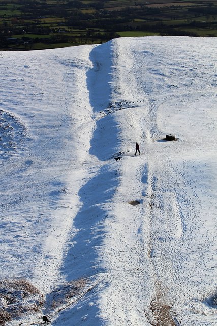
Red Earl's Dyke, The Malverns
Very visible in the sunny snow.
Looking towards Broad Down from Millennium Hill.
The dyke was created in 1287 by the "red" Earl of Gloucester, Gilbert de Clare, following a boundary dispute with the Bishop of Hereford, Thomas de Cantilupe.
It has marked the boundary between Herefordshire (to the right) and Worcestershire for many centuries.
Also visible just to the right of the ridge in the lower half of the picture is the outine of a rectangular medieval rabbit warren.
 Map © Crown Copyright")
TIP: Click the map for more Large scale mapping
- Grid Square
- SO7639, 628 images (more nearby 🔍)
- Photographer
- Bob Embleton (more nearby)
- Date Taken
- Wednesday, 14 January, 2015 (more nearby)
- Submitted
- Thursday, 15 January, 2015
- Subject Location
-
OSGB36:
 SO 761 395 [100m precision]
WGS84: 52:3.2021N 2:20.9362W - Camera Location
-
OSGB36: SO 760 395
- View Direction
- East-southeast (about 112 degrees)