M3810 : East from Dunguaire Castle
taken 10 years ago, near to Kinvarra, Co Galway, Ireland
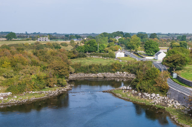
In the left background is Seapark House, now a ruin. During the famine in the mid 19th century it was used as a fever hospital.
The white thatched house in the centre of the photo dates from around 1800 and is included in the National Inventory of Architectural Heritage - see Link
Dunguaire (or Dungory) Castle was built in 1520 and was first occupied by the OHyne family, a descendant of the 7th Century King Guaire of Connacht. The earthworks on the adjacent headland is thought to have been King Guaires original fort, hence the name.
Strictly speaking the building is not a castle but more a fortified residence, popular in western Ireland in the 15th to 17th Centuries, known as a tower house.
It passed to the Martyn family of Galway in the 17th Century, and they continued to own it until 1924 when it was bought by Oliver St John Gogarty in 1924, who thought never living there carried out some repair work. Gogarty was an eminent head and neck surgeon, as well as being a poet, author, athlete and politician. He was the inspiration behind the character Buck Mulligan in James Joyces Ulysses.
The restoration was completed by Christabel, Lady Ampthill (famed for the Russell v Russell adultery or virgin birth case) who acquired the castle in 1954. It was opened to visitors in 1966 and since 1972 has been owned by the regional development body, Shannon Development. It is now a popular stop on the Burren tourist circuit, among the activities taking place there being the hosting of mediaeval banquets.
![Creative Commons Licence [Some Rights Reserved]](https://s1.geograph.org.uk/img/somerights20.gif)
|
· Find out How to reuse this image ·
Share:
|
|||||
| Start a discussion on M3810 | Suggest an update to this image | Contact the contributor | |||
- Grid Square
- M3810, 34 images (more nearby
 )
)
- Photographer
- Ian Capper (find more nearby)
- Date Taken
- Thursday, 18 September, 2014 (more nearby)
- Submitted
- Wednesday, 21 January, 2015
- Geographical Context
- Place (from Tags)
- Subject Location
-
Irish:
 M 382 106 [100m precision]
WGS84: 53:8.6004N 8:55.4289W - Camera Location
-
Irish: M 380 105
- View Direction
- Northeast (about 45 degrees)
Other Tags