J4874 : Hardford Lodge, Newtownards (January 2015)
taken 9 years ago, near to Newtownards, Co Down, Northern Ireland
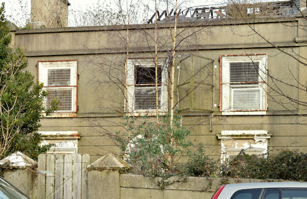
Hardford Lodge, 65 West Street, Newtownards, currently (August 2017) in a derelict state. The following description (date of creation unknown) comes from the official At Risk register This building is an unusual find in what is a narrow back street running parallel to Regent Street, one of the main thoroughfares in Newtownards. Formerly a house, it is a two-storey gabled building with outward curving wings at each end. Last used as an office, it recently suffered fire damage which has partially destroyed the roof structure, although the building appears sound..
Listed with the following description This building is shown much as today on the OS Map of c.1858-60 and may date from c.1835-40. A slight rear projection appears to have been present in c.1858, however, the present return is probably later. The wing to the east, with its two storey section to the rear, looks awkward and may not be original, however, it appears to have been constructed some considerable time ago. References- Primary sources 1 PRONI Ordnance Survey Maps, 1st Revision, 1860, Co. Down 6. 2 PRONI 2nd valuation, Newtownards, c.1863.
![Creative Commons Licence [Some Rights Reserved]](https://s1.geograph.org.uk/img/somerights20.gif)
|
· Find out How to reuse this image ·
Share:
|
|||||
| Start a discussion on J4874 | Suggest an update to this image | Contact the contributor | |||
- Grid Square
- J4874, 212 images (more nearby
 )
)
- Photographer
- Albert Bridge (find more nearby)
- Date Taken
- Monday, 26 January, 2015 (more nearby)
- Submitted
- Monday, 26 January, 2015
- Geographical Context
- Place (from Tags)
- Subject Location
-
Irish:
 J 486 743 [100m precision]
WGS84: 54:35.7212N 5:42.0971W - Camera Location
-
Irish: J 486 743
- View Direction
- NORTH (about 0 degrees)
Other Tags