J4073 : Nos 697-699 Upper Newtownards Road, Belfast (February 2015)
taken 9 years ago, near to Dundonald, Co Down, Northern Ireland
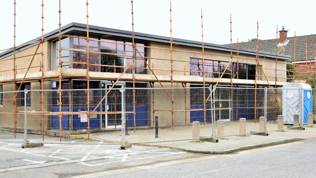
Nos 697-699 Upper Newtownards Road, Belfast (February 2015)
The former First Trust Bank is now being converted as described in the shared description (below).
Nos 697-699 Upper Newtownards Road, Belfast
An application for planning permission (Z/2014/0887/F) 697-699 Upper Newtownards Road Belfast BT4 3NT Partial change of use of existing bank premises to veterinary clinic, including a pet grooming facility and ancillary sale of pet food and accessories was approved on 23 October 2014.
The photographs submitted by me appear as a matter of geographical and historical record only. I have no connection with any of the parties involved in the sale or proposed redevelopment of the premises.
The building was numbered 697/701 Upper Newtownards Road when used by the First Trust Bank.
![Creative Commons Licence [Some Rights Reserved]](https://s1.geograph.org.uk/img/somerights20.gif)
|
· Find out How to reuse this image ·
Share:
|
|||||
| Start a discussion on J4073 | Suggest an update to this image | Contact the contributor | |||
Loading map... (JavaScript required)
- Grid Square
- J4073, 66 images (more nearby
 )
)
- Photographer
- Albert Bridge (find more nearby)
- Date Taken
- Saturday, 28 February, 2015 (more nearby)
- Submitted
- Saturday, 28 February, 2015
- Geographical Context
- Place (from Tags)
- Former (from Tags)
- Subject Location
-
Irish:
 J 404 739 [100m precision]
WGS84: 54:35.6566N 5:49.6861W - Camera Location
-
Irish: J 404 739
- View Direction
- WEST (about 270 degrees)
Other Tags
Image classification(about):
Geograph
This page has been viewed about 77 times.
View this location:
KML (Google Earth) ·
Google Maps ·
Bing Maps ·
Geograph Coverage Map ·
More Links for this image
·
Bing Maps ·
Geograph Coverage Map ·
More Links for this image