H8845 : 'B' Wing, Armagh Gaol
taken 9 years ago, near to Armagh, Northern Ireland
This is 1 of 5 images, with title 'B' Wing, Armagh Gaol in this square
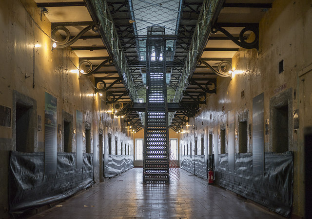
'B' Wing, Armagh Gaol
Interior view of 'B' wing at the gaol. Very similar to Crumlin Road Gaol in Belfast J3375 : Wing, Crumlin Road Gaol - and both were modelled on Pentonville in London. Most of the cells are not open to the public - nor are the two floors above.
Armagh Gaol
Former gaol in the centre of Armagh which was opened around 1780 and closed in 1986 H8745 : Armagh Prison.. The sites at Link
, Link
Parts of the building are open for tours - see Link
![Creative Commons Licence [Some Rights Reserved]](https://s1.geograph.org.uk/img/somerights20.gif)
|
· Find out How to reuse this image ·
Share:
|
|||||
| Start a discussion on H8845 | Suggest an update to this image | Contact the contributor | |||
Loading map... (JavaScript required)
- Grid Square
- H8845, 82 images (more nearby
 )
)
- Photographer
- Rossographer (find more nearby)
- Date Taken
- Saturday, 28 February, 2015 (more nearby)
- Submitted
- Monday, 2 March, 2015
- Geographical Context
- Place (from Tags)
- Subject Location
-
Irish:
 H 880 450 [100m precision]
WGS84: 54:20.7828N 6:38.8060W - Camera Location
-
Irish: H 880 450
- View Direction
- EAST (about 90 degrees)
Other Tags
Image classification(about):
Supplemental image
This page has been viewed about 142 times.
View this location:
KML (Google Earth) ·
Google Maps ·
Bing Maps ·
Geograph Coverage Map ·
More Links for this image