J3474 : Bus on the Queen Elizabeth Bridge, Belfast (March 2015)
taken 9 years ago, near to Belfast, Co Antrim, Northern Ireland
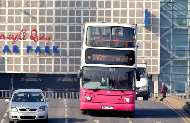
Bus on the Queen Elizabeth Bridge, Belfast (March 2015)
A Metro Alexander (Falkirk) bodied Volvo (2904 EEZ 2904) crossing the Queen Elizabeth Bridge with the 10.25 from Donegall Square West to The Braniel (5A via the Mountpottinger Road and Ladas Drive).
The Queen Elizabeth Bridge, Belfast
The Queen Elizabeth bridge, across the River Lagan, opened in 1966. Part of a one-way system, it is used by outward traffic heading towards the Sydenham bypass (for north Down), east Belfast, Newtownards and the Ards Peninsula.
![Creative Commons Licence [Some Rights Reserved]](https://s1.geograph.org.uk/img/somerights20.gif)
|
· Find out How to reuse this image ·
Share:
|
|||||
|
There are 4 posts in a
discussion on J3474 (preview on the left) |
Suggest an update to this image | Contact the contributor | |||
Loading map... (JavaScript required)
- Grid Square
- J3474, 4349 images (more nearby
 )
)
- Photographer
- Albert Bridge (find more nearby)
- Date Taken
- Wednesday, 18 March, 2015 (more nearby)
- Submitted
- Wednesday, 18 March, 2015
- Geographical Context
- Place (from Tags)
- Primary Subject of Photo
- Subject Location
-
Irish:
 J 344 744 [100m precision]
WGS84: 54:36.0132N 5:55.2570W - Camera Location
-
Irish: J 345 744
- View Direction
- WEST (about 270 degrees)
Other Tags
Image classification(about):
Geograph
This page has been viewed about 90 times.
View this location:
KML (Google Earth) ·
Google Maps ·
Bing Maps ·
Geograph Coverage Map ·
More Links for this image
·
Bing Maps ·
Geograph Coverage Map ·
More Links for this image