J3576 : The "Lisa", Belfast - May 2015(3)
taken 9 years ago, 3 km from Belfast, Co Antrim, Northern Ireland
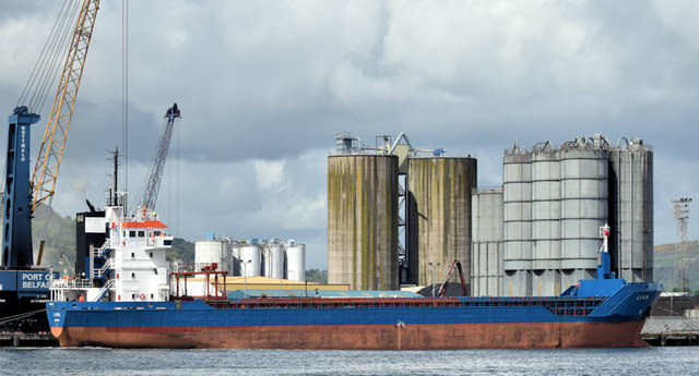
The "Lisa", Belfast - May 2015(3)
See J3576 : Harbour pilot, Belfast (May 2015). With the pilot boarded the Lisa is ready to depart once another coaster, the Eems Solar J3576 : The "Eems Solar", Belfast (May 2015), has passed. Continue to J3576 : The "Lisa", Belfast - May 2015(4).
Stormont Wharf, Belfast
Wharf at the Victoria Channel, Belfast docks. The wharf was constructed 1956-62 by Charles Brand & Son, to provide a total lineal quayage of 580 metres; this was further extended by an additional 250 metres which was completed in 2009. Stormont Wharf is now one of the longest deep water quays in Ireland.
![Creative Commons Licence [Some Rights Reserved]](https://s1.geograph.org.uk/img/somerights20.gif)
|
· Find out How to reuse this image ·
Share:
|
|||||
| Start a discussion on J3576 | Suggest an update to this image | Contact the contributor | |||
Loading map... (JavaScript required)
- Grid Square
- J3576, 974 images (more nearby
 )
)
- Photographer
- Albert Bridge (find more nearby)
- Date Taken
- Tuesday, 19 May, 2015 (more nearby)
- Submitted
- Tuesday, 19 May, 2015
- Geographical Context
- Primary Subject of Photo
- Place (from Tags)
- Subject Location
-
Irish:
 J 352 761 [100m precision]
WGS84: 54:36.8990N 5:54.4130W - Camera Location
-
Irish: J 354 758
- View Direction
- Northwest (about 315 degrees)
Other Tags
Image classification(about):
Supplemental image
This page has been viewed about 42 times.
View this location:
KML (Google Earth) ·
Google Maps ·
Bing Maps ·
Geograph Coverage Map ·
More Links for this image
·
Bing Maps ·
Geograph Coverage Map ·
More Links for this image