SD5328 : Ivy Bridge viewed from Miller Park, Preston
taken 8 years ago, near to Preston, Lancashire, England
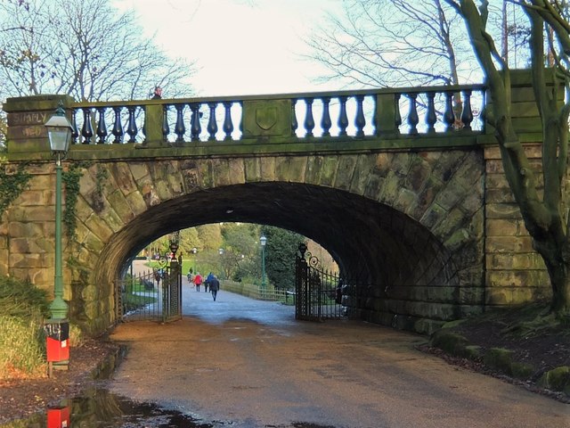
This photo recreates an earlier one taken by Ben Brooksbank in 1957: SD5328 : East Lancashire line bridge at Miller Park, with an old L&Y tank engine. Sadly, the days of trains passing over this bridge are long gone. The line is now a foot and cycle path.
This photo was taken from the Miller Park side of the bridge. Avenham Park can be seen through the arch. For the view from the other side of the bridge see SD5328 : Ivy Bridge viewed from Avenham Park, Preston.
Avenham and Miller Parks are adjoining Parks that lie in the picturesque Avenham valley on the north bank of the River Ribble close to Preston city centre and rank amongst the finest examples of traditional Victorian parkland in the country and are Grade II* listed on the English Heritage Register of Historic Gardens. The parks are separated by the East Lancashire Railway embankment and linked through ornate railway arches.
Both parks were designed and created by the renowned landscape architect Edward Milner during the 1860s. At this time the American civil war was raging and Preston and other North West cotton towns were experiencing a cotton famine due to a shortage of raw material from America. The parks were built as public works to keep cotton workers employed and prevent the social and economic problems associated with high unemployment. Miller Park is named after Thomas Miller (1811-1895) who donated the land to the west of the railway embankmentto Preston Council.
Although the parks were designed by Milner to be a "harmonious whole", his design created two distinct parks. Avenham Park became a romantic style garden whilst Miller Park is more formal in appearance with ornate floral displays. They were opened by HRH the Duke of Cambridge on 3rd October 1867.
Following a successful Heritage Lottery Bid, Avenham and Miller Parks have benefited from a substantial restoration. This project was launched in March2006, with the final phase of the restoration completed in 2014.
LinkAvenham and Miller Parks Leaflet (pdf format), Preston City Council
Opened in 1850 by the East Lancashire Railway Company, the line provided the company with a new, more direct, route from Bamber Bridge and Lostock Hall to Preston which avoided having to use the North Union Railway's line at Farington.
The route necessitated a long viaduct across the Ribble and its floodplain. This subsequently started to subside, so most of the arches were filled in to create a long embankment. At the insistence of Preston Corporation, a public footpath was provided along the viaduct across the Ribble, and Ivy Bridge (which would eventually separate Avenham and Miller parks) was given an ornate and picturesque design.
Services ran along the line from Preston to East Lancashire (via Bamber Bridge) and Ormskirk (via Lostock Hall). Preston Junction (later Todd Lane Junction) was the sole station on the line, located just north of Preston Junction: Link
The ELR was taken over by the Lancashire and Yorkshire Railway in 1859. The Whitehouse Junctions were later constructed to connect with the West Lancashire Railway Line at Penwortham*. These junctions closed in the mid-1960s, along with the WLR itself. Todd Lane Junction station remained open until 1968. Passenger services were removed in 1972 and the line closed entirely in 1977. Trains now use the less direct route through Farington which the Extension Line was built to avoid!
Today, the section of the former line south of the River Ribble and north of Brownedge Road is part of Preston Junction Nature Reserve, through which runs a public foot, cycle and bridle path. The path continues across a replacement bridge of the Ribble to Avenham and Miller Parks. It is planned that it will soon be further extended along the former trackbed to provide a direct pedestrian and cycle link to Preston Railway Station.
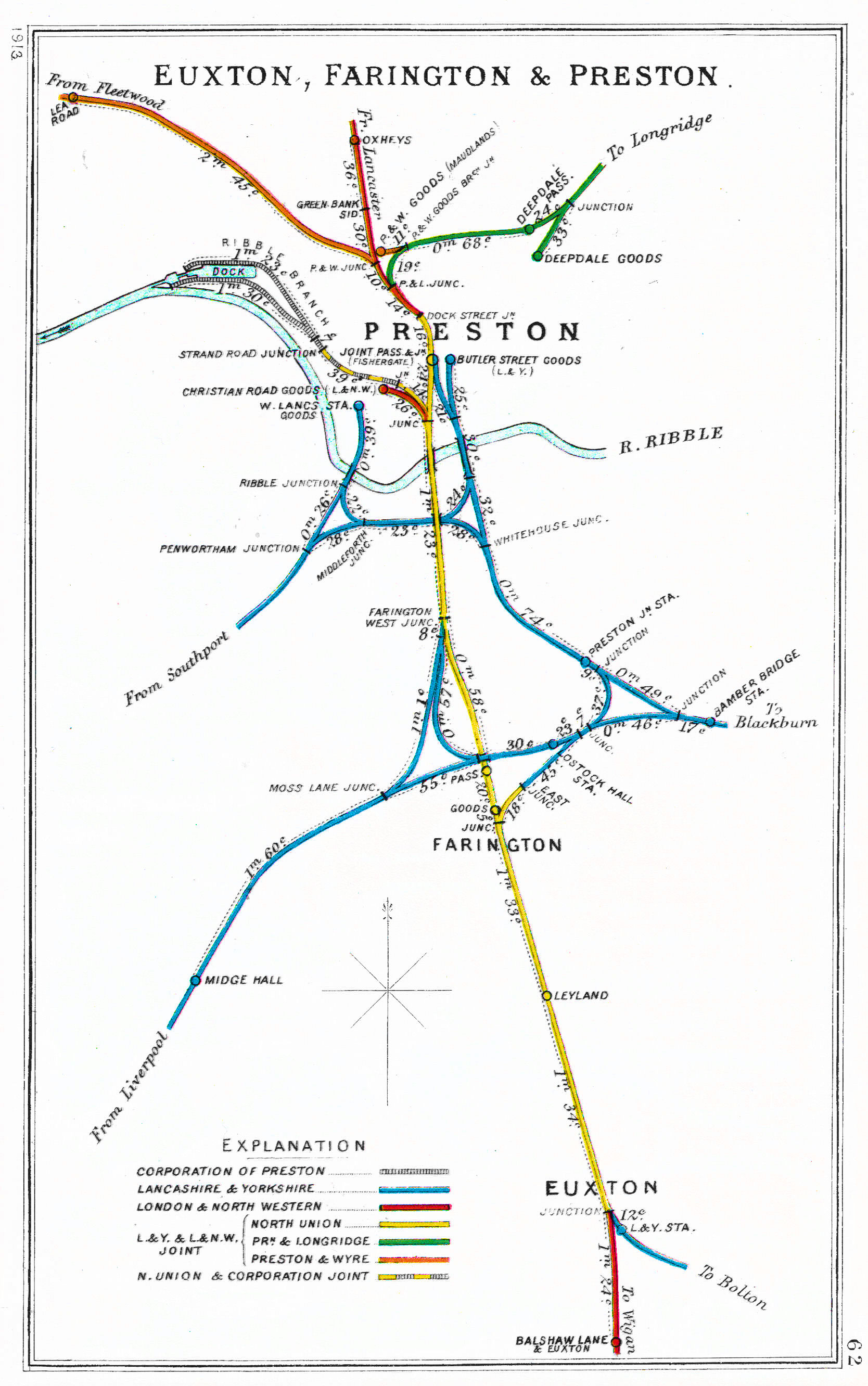
*This is a useful diagram showing Preston's once complex railway network: Link
 Map © Crown Copyright")
- Grid Square
- SD5328, 278 images (more nearby 🔍)
- Photographer
- Adam C Snape (more nearby)
- Date Taken
- Sunday, 27 December, 2015 (more nearby)
- Submitted
- Monday, 28 December, 2015
- Subject Location
-
OSGB36:
 SD 5371 2874 [10m precision]
WGS84: 53:45.1774N 2:42.2098W - Camera Location
-
OSGB36: SD 5369 2873
- View Direction
- Northeast (about 45 degrees)