2016
SK5361 : Mansfield - The Co-op Bank and Beales Department Store
taken 8 years ago, near to Mansfield, Nottinghamshire, England
This is 1 of 9 images, with title starting with Mansfield - The in this square
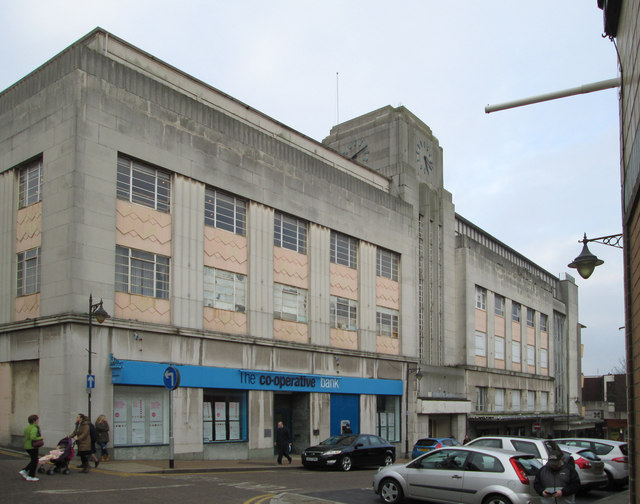
Mansfield - The Co-op Bank and Beales Department Store
This building on Queen Street currently houses the Cooperative Bank and Beales Department Store. The main entrances to Beales are on the neighbouring Stockwell Gate.
A brief history of the Mansfield Co-operative Society follows below.
1864: The Mansfield Co-operative Society is formed.
1914: By this date the Co-op was operated by the Mansfield & Sutton Co-operative, according to the war memorial plaque now sited in the Queen Street premises.
1918: The store on Stockwell Gate was destroyed in a fire.
1922: The new and enlarged Mansfield & Sutton Co-operative store, Stockwell Gate, opens on the site of that destroyed by fire in 1918.
1938: The Queen Street building was officially opened.
1970: The Co-operative Societies of Mansfield & Sutton, Pleasley, Pleasley Hill, and Clowne, were merged.
1983: The Greater Nottingham and the Mansfield and Worksop Co-operative Societies agreed to merge.
1984: A Co-op Superstore was opened on the site of the old Portland Wharf, Station Street.
2006: The Greater Nottingham Coop transferred its department store businesses (including the one in Mansfield) to the Anglia Co-operative Society and the stores were rebranded as "Westgate" (not to be confused with the nearby street name in Mansfield).
2011: The Anglia Society sold the business of its 19 Westgate Department Stores, including the one in Mansfield, to Beales.
Most of the above information is provided at Link , but other information has been provided by Link , Link , Link , and Link (Archive Link ) .
A brief history of the Mansfield Co-operative Society follows below.
1864: The Mansfield Co-operative Society is formed.
1914: By this date the Co-op was operated by the Mansfield & Sutton Co-operative, according to the war memorial plaque now sited in the Queen Street premises.
1918: The store on Stockwell Gate was destroyed in a fire.
1922: The new and enlarged Mansfield & Sutton Co-operative store, Stockwell Gate, opens on the site of that destroyed by fire in 1918.
1938: The Queen Street building was officially opened.
1970: The Co-operative Societies of Mansfield & Sutton, Pleasley, Pleasley Hill, and Clowne, were merged.
1983: The Greater Nottingham and the Mansfield and Worksop Co-operative Societies agreed to merge.
1984: A Co-op Superstore was opened on the site of the old Portland Wharf, Station Street.
2006: The Greater Nottingham Coop transferred its department store businesses (including the one in Mansfield) to the Anglia Co-operative Society and the stores were rebranded as "Westgate" (not to be confused with the nearby street name in Mansfield).
2011: The Anglia Society sold the business of its 19 Westgate Department Stores, including the one in Mansfield, to Beales.
Most of the above information is provided at Link
 Map © Crown Copyright")
TIP: Click the map for more Large scale mapping
- Grid Square
- SK5361, 255 images (more nearby 🔍)
- Photographer
- Dave Bevis (more nearby)
- Date Taken
- Friday, 12 February, 2016 (more nearby)
- Submitted
- Wednesday, 17 February, 2016
- Subject Location
-
OSGB36:
 SK 5375 6105 [10m precision]
WGS84: 53:8.6336N 1:11.8726W - Camera Location
-
OSGB36: SK 5375 6104
- View Direction
- Northwest (about 315 degrees)