2016
NS6066 : Sighthill high rise demolition & contamination
taken 8 years ago, near to Royston, Glasgow, Scotland
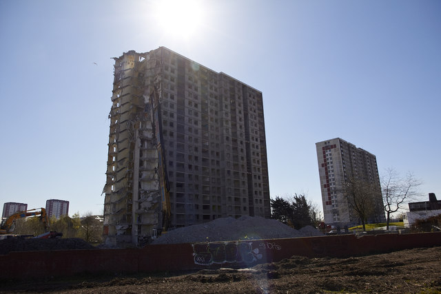
Sighthill high rise demolition & contamination
Theres a terrible smell all over Glasgows Sighthill Park and while one worker drilled into the ground he told me the land is contaminated as black stinking sludge came out of the ground.
It looks like burst sewage pipes are to blame for the gigantic mess judging by all the scarring of the land. While in the background demolition teams set about removing one of the last two high rise tower blocks along the main road.
Youll find other images here : Link (Archive Link )
It looks like burst sewage pipes are to blame for the gigantic mess judging by all the scarring of the land. While in the background demolition teams set about removing one of the last two high rise tower blocks along the main road.
Youll find other images here : Link
 Map © Crown Copyright")
TIP: Click the map for more Large scale mapping
- Grid Square
- NS6066, 100 images (more nearby 🔍)
- Photographer
- david cameron photographer (more nearby)
- Date Taken
- Thursday, 21 April, 2016 (more nearby)
- Submitted
- Saturday, 23 April, 2016
- Subject Location
-
OSGB36:
 NS 6012 6671 [10m precision]
WGS84: 55:52.3912N 4:14.2336W - Camera Location
-
OSGB36: NS 6011 6673
- View Direction
- South-southeast (about 157 degrees)