TG0444 : Cley next the Sea
taken 8 years ago, near to Cley Next The Sea, Norfolk, England
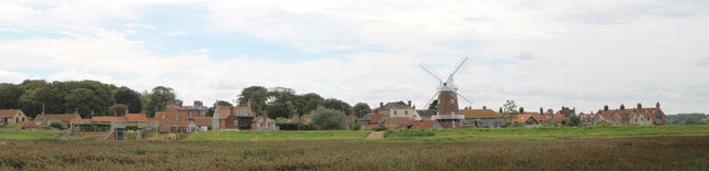
Cley next the Sea Anglo-Saxon Clæg "clay", is a village on the River Glaven in Norfolk, 4 miles north-west of Holt and east of Blakeney. The main A149 coast road runs through the centre of the village, causing congestion in the summer months due to the tight, narrow streets. It lies within the Norfolk Coast AONB (Area of Outstanding Natural Beauty) and the North Norfolk Heritage Coast.
Cley was once a very important port, but land reclaimation means that it is no longer "next the sea".
The village has a range of services including a shop, pub and windmill (function room).
Wikipedia: Link
Cley Windmill is a grade II* listed tower mill at Cley next the Sea, which has been converted to a guesthouse offering B&B, wedding receptions and self catering accommodation
Website: Link
Wikipedia: Link
The Norfolk Coast Path is a long distance footpath in Norfolk, running 45 miles from Hunstanton to Cromer. It was opened in 1986 and covers the North Norfolk Coast AONB (Area of Outstanding Natural Beauty).
It links with the Peddars Way at Holme-next-the-Sea, and the two in combination form the Peddars Way & Norfolk Coast Path National Trail. At Cromer it links to the Weavers Way.
 Map © Crown Copyright")
- Grid Square
- TG0444, 340 images (more nearby 🔍)
- Photographer
- Dave Pickersgill (more nearby)
- Date Taken
- Saturday, 3 September, 2016 (more nearby)
- Submitted
- Tuesday, 6 September, 2016
- Subject Location
-
OSGB36:
 TG 045 440 [100m precision]
WGS84: 52:57.2896N 1:2.5738E - Camera Location
-
OSGB36: TG 044 448
- View Direction
- SOUTH (about 180 degrees)