J3474 : Nos 34-36 Chichester Street (demolition), Belfast (July 2017)
taken 7 years ago, near to Belfast, Co Antrim, Northern Ireland
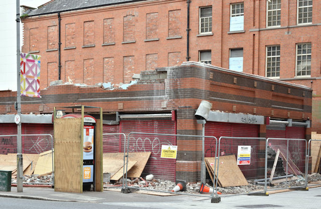
Nos 34-36 Chichester Street (demolition), Belfast (July 2017)
Most of the building has been demolished. Note the protection applied to the telephone box and road sign (middle right).
Erskine House, Chichester Street/Arthur Street, Belfast
A site at 20/36 Chichester Street and 28/36 Arthur Street with the following planning permission (17 February 2017) LA04/2016/1789/F Demolition of existing building at 34-36 Chichester Street and erection of new 8No. storey mixed use development incorporating retail and office ground floor, and 1st-7th floor offices with associated external plant. 7-9 Arthur Street 20-32 Chichester Street and existing building at 34-36 Chichester Street Belfast.
The completed building will be occupied by HM Revenue and Customs.
![Creative Commons Licence [Some Rights Reserved]](https://s1.geograph.org.uk/img/somerights20.gif)
|
· Find out How to reuse this image ·
Share:
|
|||||
|
There are 4 posts in a
discussion on J3474 (preview on the left) |
Suggest an update to this image | Contact the contributor | |||
Loading map... (JavaScript required)
- Grid Square
- J3474, 4349 images (more nearby
 )
)
- Photographer
- Albert Bridge (find more nearby)
- Date Taken
- Sunday, 16 July, 2017 (more nearby)
- Submitted
- Sunday, 16 July, 2017
- Geographical Context
- Place (from Tags)
- Primary Subject of Photo
- Subject Location
-
Irish:
 J 340 741 [100m precision]
WGS84: 54:35.8521N 5:55.6087W - Camera Location
-
Irish: J 340 741
- View Direction
- Northwest (about 315 degrees)
Other Tags
This page has been viewed about 76 times.
View this location:
KML (Google Earth) ·
Google Maps ·
Bing Maps ·
Geograph Coverage Map ·
More Links for this image
·
Bing Maps ·
Geograph Coverage Map ·
More Links for this image