Geograph - photograph every grid square
2017
SX5569
: Lowery Barn
taken
7 years ago
,
near
to
Sheepstor
, Devon, England
This is 1 of
2 images, with title Lowery Barn
in this square
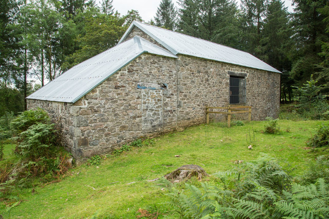
Lowery Barn
Marked on the OS maps as Lower Lowery this barn has been preserved for posterity. Compare with
SX5569 : Lower Lowery
taken in 2010.
© Copyright
Guy Wareham
and licensed for
reuse
under this
Creative Commons Licence
.
Licensing
Download
More Sizes
Share...
Share this photo via Twitter
Share this photo via Facebook
Share this photo via Pinterest
Share this photo via Flipboard
Share this photo via email/e-card
Grab a Stamped/Watermarked Image
Mark
👍🏻
Like Image
👍🏻
Like Description
Update Information
Contact Contributor
Geographical Context:
Historic sites and artefacts
Farm, Fishery, Market Gardening
Derelict, Disused
Woodland, Forest
Primary Subject:
Barn
This photo is linked from:
Automatic Clusters
: ·
Lower Lowery [5]
·
Lowery Barn [2]
Title Clusters
: ·
Lowery Barn [2]
·
TIP: Click the map for more Large scale mapping
Grid Square
SX5569
, 23 images (
more nearby
🔍
)
Photographer
Guy Wareham
(
more nearby
)
Date Taken
Thursday, 24 August, 2017 (
more nearby
)
Submitted
Friday, 25 August, 2017
Subject Location
OSGB36:
SX 5564 6924
[10m precision]
WGS84:
50:30.3068N
4:2.2261W
Camera Location
OSGB36:
SX 5565 6926
View Direction
Southwest (about 225 degrees)
NW
N
NE
W
Go
E
SW
S
SE
Discuss SX5569
View this location on ...
Geograph Coverage Map (includes OSM etc)
Geograph Links Page
Open in Google Maps
Navigate to location with Google Maps
Open in Google Earth Pro
Open in Google Earth for Web
Open in Bing Maps
Navigate with Google Maps
Lookup nearest Postcode
Image Type
(about)
:
geograph
This page has been
viewed
about
28
times
☰
Home
View
Search
Marked Images
Maps
Browser
Explore
Showcase
New Images
Collections
Interact
Games
Discussions
Blog
Contributors
Submit
Statistics
Leaderboards
General
FAQ
Help Pages
Sitemap
Contact Us
Support Us
sponsored by
🔍
What to search:
Photos
Enter keywords or a location/postcode to search nearby images
Photos near SX5569
Enter a Grid Reference
Placenames
Collections
Website Pages
Everything
Others:
Advanced Search
|
Image Browser
Or:
Coverage Map
|
Searchable Map
You are not logged in
login
|
register